1962 Map of Milford
USGS Topo · Published 1963About this map
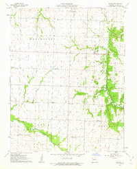
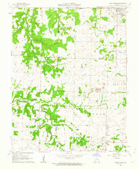
Milford serves as the primary settlement center of this rural Missouri landscape, situated near the confluence of Horse Creek and Ring Branch. The 1962 field checks by the Geological Survey document a highly developed network of rural social infrastructure, characterized by a high density of country schools and churches that defined mid-century Barton County. Educational life is anchored by scattered sites like Prairie Rose Sch, Cherry Grove Sch, and Doylesport Sch, reflecting a township-based community structure.
Find a feature on this map
29 named features on this map. Tap any name to fly to it.
Don’t see what you’re looking for? This feature index may not catch every label — zoom into the map to look around manually.
Map Details
Editions of this 1962 Milford Map
This is the sole edition of this map. No revisions or reprints were ever made.
Other maps of this area

1886 · Nevada
USGS Topo · 1:125,000

1886 · Carthage
USGS Topo · 1:125,000

1894 · Nevada
USGS Topo · 1:125,000

1894 · Carthage
USGS Topo · 1:125,000

1947 · Joplin
USGS Topo · 1:250,000

1949 · Joplin
USGS Topo · 1:250,000

1954 · Joplin
USGS Topo · 1:250,000

1958 · Joplin
USGS Topo · 1:250,000

1959 · Joplin
USGS Topo · 1:250,000
1962 · Jerico Springs
USGS Topo · 1:24,000