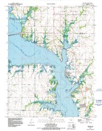
1991 Map of Milford
USGS Topo · Published 1995About this map
Milford Lake dominates this geography, where the Republican River was impounded to create a massive reservoir northwest of Junction City. The town of Milford sits along the eastern shore, adjacent to the sprawling Fort Riley Military Reservation which occupies the northern and eastern portions of the quadrangle. This 1991 revision reflects the area's development as a primary recreational and military hub, featuring numerous public use areas like Timber Creek Public Use Area and Farnum Creek Public Use Area. Beyond the water, the terrain rises toward Fragrant Hill and Smoky Hill in the south, where the Smoky Hill River cuts across the corner. Local history is anchored by sites like the Milford Cem and several Gravel Pit or Quarry operations, illustrating the transition from traditional river valley agriculture to a landscape defined by water management and military training.
Find a feature on this map
27 named features on this map. Tap any name to fly to it.
Don’t see what you’re looking for? This feature index may not catch every label — zoom into the map to look around manually.
Map Details
Editions of this 1991 Milford Map
This is the sole edition of this map. No revisions or reprints were ever made.
Other maps of this area

1886 · Junction City
USGS Topo · 1:125,000

1889 · Junction City
USGS Topo · 1:125,000

1891 · Clay Center
USGS Topo · 1:125,000

1894 · Junction City
USGS Topo · 1:125,000

1947 · Fort Riley
USGS Topo · 1:62,500

1950 · Junction City
USGS Topo · 1:24,000

1950 · Alida
USGS Topo · 1:24,000

1951 · Wind Creek
USGS Topo · 1:24,000

1951 · Milford
USGS Topo · 1:24,000

1955 · Fort Riley NE
USGS Topo · 1:24,000