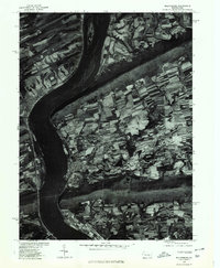
1977 Map of Millersburg
USGS Topo · Published 1979About this map
The Susquehanna River dominates this orthophotomap, carving a wide path through the central Pennsylvania ridges in the late 1970s. The riverside settlement of Millersburg sits at the base of the agricultural uplands, with the smaller community of Lenkerville situated just to the south. Across the water, Liverpool lines the western bank. The landscape is defined by the rigid, forested spines of Mahantango Mountain to the north and Berry Mountain to the south, which squeeze the river into a tight corridor. Between these landmarks, a complex patchwork of strip-farming and woodlots reveals the area's agricultural character. This 1977 aerial perspective, produced in cooperation with the Soil Conservation Service, provides a clear view of the land-use patterns and township boundaries as they existed before modern suburban expansion significantly altered the rural layout.
Find a feature on this map
6 named features on this map. Tap any name to fly to it.
Don’t see what you’re looking for? This feature index may not catch every label — zoom into the map to look around manually.
Map Details
Editions of this 1977 Millersburg Map
This is the sole edition of this map. No revisions or reprints were ever made.
Other maps of this area

1892 · Harrisburg
USGS Topo · 1:62,500

1893 · Millersburg
USGS Topo · 1:62,500

1899 · Harrisburg
USGS Topo · 1:62,500

1907 · New Bloomfield
USGS Topo · 1:62,500

1907 · Millerstown
USGS Topo · 1:62,500

1924 · Harrisburg
USGS Topo · 1:62,500

1943 · Millerstown
USGS Topo · 1:62,500

1943 · Millersburg
USGS Topo · 1:62,500

1943 · Harrisburg
USGS Topo · 1:62,500

1943 · New Bloomfield
USGS Topo · 1:62,500
Featured Places
- Jackson Township, PA
- Mifflin Township, PA
- Liverpool, PA
- Paxton, Upper Paxton Township
- Cloverly Acres, Upper Paxton Township