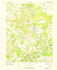
1954 Map of Millerstown
USGS Topo · Published 1955About this map
The Nolin River winds through this rural landscape on the borders of Hardin, Grayson, and Hart Counties, creating dramatic loops such as Bush Bend and passing by Joyce Island. This mid-century snapshot reveals a dispersed network of farming communities and family-named landmarks like Akers Valley and Fox Den Hill. Small, localized industries are evident along the riverbanks, where both Wheelers Mill and Riders Mill represent the area's historical reliance on water power for milling.
Find a feature on this map
58 named features on this map. Tap any name to fly to it.
Don’t see what you’re looking for? This feature index may not catch every label — zoom into the map to look around manually.
Map Details
Editions of this 1954 Millerstown Map
This is the sole edition of this map. No revisions or reprints were ever made.
Other maps of this area

1925 · Cub Run
USGS Topo · 1:62,500

1932 · Big Clifty
USGS Topo · 1:62,500

1934 · Munfordville
USGS Topo · 1:48,000

1935 · Elizabethtown
USGS Topo · 1:48,000

1937 · Munfordville
USGS Topo · 1:62,500

1938 · Elizabethtown
USGS Topo · 1:62,500

1949 · Sonora
USGS Topo · 1:24,000

1949 · Summit
USGS Topo · 1:24,000

1949 · Big Clifty
USGS Topo · 1:24,000

1949 · Big Clifty
USGS Topo · 1:62,500