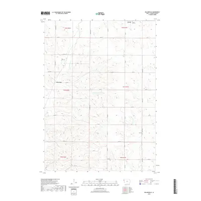
2018 Map of Millnerville
USGS Topo · Published 2018About this map
Millnerville and Adaville anchor this corner of Plymouth County, where a network of section roads like Dogwood Ave and Granite Ave crisscross a landscape defined by the drainages of the Missouri River watershed. The area's social history is preserved through scattered burial grounds, including the Mills Family Cem located near the banks of Broken Kettle Cr, and the Pleasant Valley Cem to the north. These small, family-linked sites offer critical waypoints for genealogical research in a region dominated by agriculture. The hydrology is shaped by the winding paths of Deer Cr and the W Br Perry Cr, while the Pavlik Lakes provide a localized break in the terrain. This survey reflects the enduring grid-based settlement pattern of the Iowa prairie, where historical township lines like t91n r48w still dictate the modern rural layout.
Find a feature on this map
39 named features on this map. Tap any name to fly to it.
Don’t see what you’re looking for? This feature index may not catch every label — zoom into the map to look around manually.
Map Details
Editions of this 2018 Millnerville Map
This is the sole edition of this map. No revisions or reprints were ever made.
Other maps of this area

1898 · Elk Point
USGS Topo · 1:125,000

1901 · Elk Point
USGS Topo · 1:125,000

1907 · Elk Point
USGS Topo · 1:125,000

1955 · Sioux City
USGS Topo · 1:250,000

1958 · Sioux City
USGS Topo · 1:250,000

1959 · Sioux City
USGS Topo · 1:250,000

1963 · Sioux City North
USGS Topo · 1:24,000

1963 · Elk Point NE
USGS Topo · 1:24,000

1963 · Jefferson
USGS Topo · 1:24,000

1964 · James
USGS Topo · 1:24,000