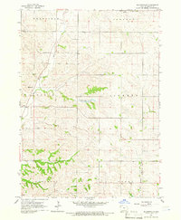
1964 Map of Millnerville
USGS Topo · Published 1966About this map
Millnerville and Adaville anchor this mid-1960s survey of the Plymouth County landscape, where the terrain transitions into the loess hills of western Iowa. The map documents a predominantly agrarian community organized across the townships of Sioux, Liberty, and Johnson. The drainage patterns are defined by the meandering Broken Kettle Creek in the west and the West Branch Perry Creek in the southeast, with the Pavlik Lakes appearing as a localized water feature. Genealogists can identify several key community landmarks, including Pleasant Valley Cem near the northern boundary and Liberty Cem further south. A rural Sch near Sunnyside reflects the era's remaining local school infrastructure amidst the vast sections of farmland and timbered draws that characterize this part of the Missouri River watershed.
Find a feature on this map
16 named features on this map. Tap any name to fly to it.
Don’t see what you’re looking for? This feature index may not catch every label — zoom into the map to look around manually.
Map Details
Editions of this 1964 Millnerville Map
This is the sole edition of this map. No revisions or reprints were ever made.
Other maps of this area

1898 · Elk Point
USGS Topo · 1:125,000

1901 · Elk Point
USGS Topo · 1:125,000

1907 · Elk Point
USGS Topo · 1:125,000

1955 · Sioux City
USGS Topo · 1:250,000

1958 · Sioux City
USGS Topo · 1:250,000

1959 · Sioux City
USGS Topo · 1:250,000

1963 · Sioux City North
USGS Topo · 1:24,000

1963 · Elk Point NE
USGS Topo · 1:24,000

1963 · Jefferson
USGS Topo · 1:24,000

1964 · James
USGS Topo · 1:24,000