1954 Map of Minneapolis
USGS Topo · Published 1959About this map
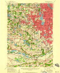
The Mississippi River and the sweeping bend of the Minnesota River frame this mid-century view of the Twin Cities' western expansion. During the early 1950s, the urban grid of Minneapolis pushes westward through St Louis Park and Richfield, while outlying areas like Eden Prairie and Bloomington remain largely rural, dotted with country schools and family cemeteries. The landscape is defined by its glacial history, with a high concentration of lakes such as Lake Calhoun, Lake Harriet, and Medicine Lake interspersed with extensive parklands like Glenwood Park. Transport and industry are centered on the river valleys and rail lines, evidenced by the industrial activity at Port Cargill and the presence of the Northern Pacific and Chicago and North Western railroads. Notable specialized sites include the Glen Lake Sanatorium and the Minnesota Masonic Home, reflecting the era's institutional development on the suburban fringe.
Find a feature on this map
163 named features on this map. Tap any name to fly to it.
Don’t see what you’re looking for? This feature index may not catch every label — zoom into the map to look around manually.
Map Details
Editions of this 1954 Minneapolis Map
This is the sole edition of this map. No revisions or reprints were ever made.
Other maps of this area

1896 · Minneapolis
USGS Topo · 1:62,500

1896 · St. Paul
USGS Topo · 1:62,500

1901 · Minneapolis
USGS Topo · 1:62,500

1902 · White Bear
USGS Topo · 1:62,500

1902 · Anoka
USGS Topo · 1:62,500

1905 · Minnetonka
USGS Topo · 1:62,500

1907 · Minnetonka
USGS Topo · 1:62,500

1909 · Rockford
USGS Topo · 1:62,500

1951 · St. Paul West
USGS Topo · 1:24,000

1951 · St. Paul SW
USGS Topo · 1:24,000