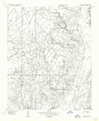
1955 Map of Moa Ave SW
USGS Topo · Published 1957About this map
The Navajo Indian Reservation landscape within Coconino County is defined here by the seasonal drainage patterns of Moenkopi Wash and Hamblin Wash. This mid-century survey reveals a sparse settlement pattern of traditional dwellings, with several Hogans and a singular Hogan or House scattered across the high desert terrain. A lone Prospect near the center of the map indicates mineral exploration, while a Tank in the northwest suggests the vital importance of water management in this arid region. The topography is meticulously detailed through 40-foot contours, capturing the intricate mesas and draws typical of the Arizona plateau. This preliminary edition, derived from 1953 aerial photography, preserves the locations of these family-centered landmarks before later developments altered the local geography.
Find a feature on this map
9 named features on this map. Tap any name to fly to it.
Don’t see what you’re looking for? This feature index may not catch every label — zoom into the map to look around manually.
Map Details
Editions of this 1955 Moa Ave SW Map
This is the sole edition of this map. No revisions or reprints were ever made.
Other maps of this area

1886 · San Francisco Mtns
USGS Topo · 1:250,000

1886 · Echo Cliffs
USGS Topo · 1:250,000

1891 · San Francisco Mtns
USGS Topo · 1:250,000

1891 · Echo Cliffs
USGS Topo · 1:250,000

1894 · San Francisco Mtns
USGS Topo · 1:250,000

1899 · San Francisco Mtns
USGS Topo · 1:250,000

1947 · Flagstaff
USGS Topo · 1:250,000

1954 · Flagstaff
USGS Topo · 1:250,000

1955 · Coconino Pt NE
USGS Topo · 1:24,000

1955 · Blue Spring NE
USGS Topo · 1:24,000