
Loading...
Loading map...2021 Map of Monett
USGS Topo · Published 2021About this map
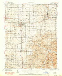
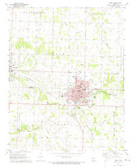
Monett serves as the primary hub of this Southwest Missouri landscape, situated at the boundary of Lawrence and Barry Counties. The map reveals a high density of community anchors, particularly numerous cemeteries such as Mount Calvary Cem, Oakdale Cem, and Saint Johns Cem within the city limits. Further west, Pierce City stands as a distinct center with its own dedicated Pierce City Cem and the neighboring Saint Mary's Cem and Saint Patrick's Cem.
Find a feature on this map
67 named features on this map. Tap any name to fly to it.
Don’t see what you’re looking for? This feature index may not catch every label — zoom into the map to look around manually.
Map Details
Date Portrayed2021
Date Published2021
PublisherU.S. Geological Survey
Map TypeTopographic
Scale1:24000
Physical Dimensions24 x 29 inches
Editions of this 2021 Monett Map
This is the sole edition of this map. No revisions or reprints were ever made.
Historical Maps of Monett Through Time
Featured Locations
Source Details
SourceU.S. Geological Survey
CopyrightPublic Domain