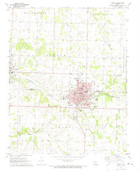
1972 Map of Monett
USGS Topo · Published 1973About this map
The town of Monett serves as a significant hub on the St Louis - San Francisco rail line, straddling the border of Lawrence and Barry counties. This early 1970s survey captures a well-established community defined by its civic and educational infrastructure, from the Monett State Training School and Forest Park School to the hospital and airport. To the west, the smaller settlement of Pierce City is anchored by St Marys Cemetery and Central School. The landscape is etched with small waterways like Kelly Creek and Clear Creek, while the presence of the Waldensian Church and numerous cemeteries such as Mt Calvary and Oakdale points to a landscape deeply rooted in family and denominational history. Beyond the town limits, features like a drive-in theater and golf course reflect the mid-century suburban expansion into the surrounding King Prairie.
Find a feature on this map
53 named features on this map. Tap any name to fly to it.
Don’t see what you’re looking for? This feature index may not catch every label — zoom into the map to look around manually.
Map Details
Editions of this 1972 Monett Map
This is the sole edition of this map. No revisions or reprints were ever made.
Other maps of this area

1886 · Greenfield
USGS Topo · 1:125,000

1886 · Carthage
USGS Topo · 1:125,000

1888 · Greenfield
USGS Topo · 1:125,000

1894 · Carthage
USGS Topo · 1:125,000

1921 · Stotts City
USGS Topo · 1:62,500

1921 · Sarcoxie
USGS Topo · 1:62,500

1943 · Ritchey
USGS Topo · 1:62,500

1943 · Monett
USGS Topo · 1:62,500

1945 · Harrison
USGS Topo · 1:250,000

1947 · Joplin
USGS Topo · 1:250,000