1986 Map of Mono Mills
USGS Topo · Published 1986About this map
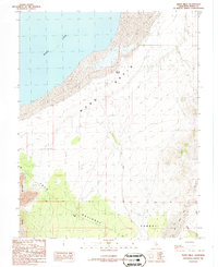
Mono Mills serves as the focal point of this mid-1980s landscape, positioned near the southern edge of the Mono National Forest. The map documents a rugged transition from the volcanic geography of the Lava Rim and Craters in the west toward the distinctive shoreline of Mono Lake and the Mono Basin in the north. Evidence of the region’s industrial and resource-extraction history is scattered throughout the terrain, indicated by numerous Prospects and a Gravel Pit. Most notably, the Old Railroad Grade winds through the area, tracing the path of former timber and supply transport that once supported local milling operations. Hydrological features like Simons Spring and the ephemeral Dry Creek emphasize the arid nature of this high-desert environment, while the Base Line survey boundary cuts horizontally across the central topography.
Find a feature on this map
16 named features on this map. Tap any name to fly to it.
Don’t see what you’re looking for? This feature index may not catch every label — zoom into the map to look around manually.
Map Details
Editions of this 1986 Mono Mills Map
This is the sole edition of this map. No revisions or reprints were ever made.
Other maps of this area

1901 · Mt. Lyell
USGS Topo · 1:125,000

1909 · Hawthorne
USGS Topo · 1:250,000

1909 · Bridgeport
USGS Topo · 1:125,000

1911 · Bridgeport
USGS Topo · 1:125,000

1911 · Hawthorne
USGS Topo · 1:250,000

1914 · Mt. Morrison
USGS Topo · 1:125,000

1915 · Hawthorne
USGS Topo · 1:250,000

1920 · Bridgeport
USGS Topo · 1:125,000

1947 · Mariposa
USGS Topo · 1:250,000

1948 · Walker Lake
USGS Topo · 1:250,000