1971 Map of Monroe
USGS Topo · Published 1989About this map
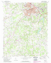
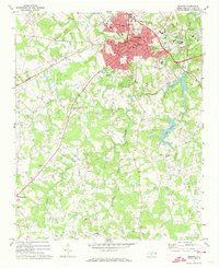
Monroe serves as the focal point of this 1970s landscape, illustrating a period of notable growth as urban expansion, indicated by purple revisions, pushes into the surrounding Union County countryside. The city center is densely detailed with civic landmarks including the Filtration Plant, Union Hospital, and the Armory. The Seaboard Coast Line railroad cuts through the terrain, anchoring the local economy and transportation network. To the east and south, the landscape is defined by the waters of Lake Monroe and Lake Lee, while the rural areas are dotted with community hubs like Roughedge and Alton. Numerous rural sanctuaries such as Mount Carmel Ch, Corinth Ch, and New Hope Ch appear alongside family and community burial grounds like Hillcrest Cem and Suncrest Cem, providing valuable spatial data for genealogists and local historians tracing the development of these North Carolina communities.
Find a feature on this map
43 named features on this map. Tap any name to fly to it.
Don’t see what you’re looking for? This feature index may not catch every label — zoom into the map to look around manually.
Map Details
Editions of this 1971 Monroe Map
2 editions found
Other maps of this area

1941 · Charlotte
USGS Topo · 1:125,000

1941 · Spartanburg
USGS Topo · 1:250,000

1942 · Charlotte
USGS Topo · 1:125,000

1953 · Spartanburg
USGS Topo · 1:250,000

1953 · Charlotte
USGS Topo · 1:250,000

1954 · Charlotte
USGS Topo · 1:250,000

1960 · Charlotte
USGS Topo · 1:250,000

1960 · Spartanburg
USGS Topo · 1:250,000

1962 · Charlotte
USGS Topo · 1:250,000

1963 · Spartanburg
USGS Topo · 1:250,000