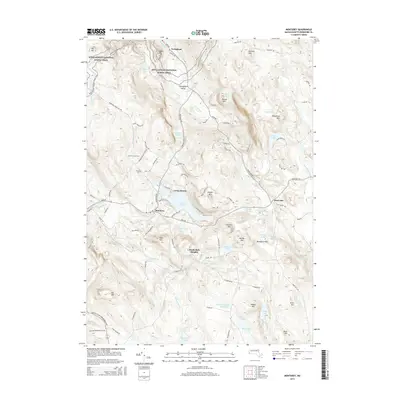
2015 Map of Monterey
USGS Topo · Published 2015About this map
The Berkshire Hills define the high country of this mid-2010s survey, where the Appalachian National Scenic Trail winds through the northern elevations past Sky Hill and Shaker Pond. This landscape is centered on the town of Monterey, positioned at the junction of the Konkapot River and the significant waters of Lake Garfield. The map reveals a cluster of interior settlements and recreational areas, including Hephzibah Heights and Camp Jayson, alongside smaller hamlets like Tyringham and West Otis. Local history and genealogy are anchored by the presence of Old Center Cem and Woods Cem, located near the historic road networks of Tyringham Valley. Numerous water bodies, from the Morley Swamp Reservoir to Stedman Pond, reflect the complex drainage system of the Clam River and Buck River basins that have long shaped the valley's development and industry.
Find a feature on this map
103 named features on this map. Tap any name to fly to it.
Don’t see what you’re looking for? This feature index may not catch every label — zoom into the map to look around manually.
Map Details
Editions of this 2015 Monterey Map
This is the sole edition of this map. No revisions or reprints were ever made.
Other maps of this area

1885 · Sheffield
USGS Topo · 1:62,500

1886 · Becket
USGS Topo · 1:62,500

1888 · Sheffield
USGS Topo · 1:62,500

1888 · Becket
USGS Topo · 1:62,500

1888 · Sandisfield
USGS Topo · 1:62,500

1888 · Pittsfield
USGS Topo · 1:62,500

1890 · Pittsfield
USGS Topo · 1:62,500

1891 · Sheffield
USGS Topo · 1:62,500

1893 · Becket
USGS Topo · 1:62,500

1893 · Sheffield
USGS Topo · 1:62,500