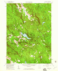
1958 Map of Monterey
USGS Topo · Published 1960About this map
Lake Garfield sits at the heart of this Berkshire County landscape, where the town of Monterey and its surrounding hill country are captured just before the 1960s. The map illustrates a region defined by extensive woodlands and recreation, dominated by the Beartown State Forest, Otis State Forest, and Sandisfield State Forest. A complex network of seasonal camps and spiritual retreats, including Camp Meadowlark, Camp Glenmere, and the New England Keswick Ch, suggests the area's mid-century role as a summer destination.
Find a feature on this map
72 named features on this map. Tap any name to fly to it.
Don’t see what you’re looking for? This feature index may not catch every label — zoom into the map to look around manually.
Map Details
Editions of this 1958 Monterey Map
2 editions found
Other maps of this area

1885 · Sheffield
USGS Topo · 1:62,500

1886 · Becket
USGS Topo · 1:62,500

1888 · Sheffield
USGS Topo · 1:62,500

1888 · Becket
USGS Topo · 1:62,500

1888 · Sandisfield
USGS Topo · 1:62,500

1888 · Pittsfield
USGS Topo · 1:62,500

1890 · Pittsfield
USGS Topo · 1:62,500

1891 · Sheffield
USGS Topo · 1:62,500

1893 · Becket
USGS Topo · 1:62,500

1893 · Sheffield
USGS Topo · 1:62,500