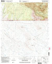
2004 Map of Montezuma Pass
USGS Topo · Published 2007About this map
The Huachuca Mountains dominate this high-desert terrain where the international boundary between the United States of America and Mexico bisects the landscape. This 2004 revision details the overlapping jurisdictions of the Miller Peak Wilderness, Coronado National Forest, and the Coronado National Memorial. The mapping reflects a complex geography of resource extraction and conservation, specifically noting the State of Texas Mine and the Modern Mine amidst numerous scattered prospects.
Find a feature on this map
54 named features on this map. Tap any name to fly to it.
Don’t see what you’re looking for? This feature index may not catch every label — zoom into the map to look around manually.
Map Details
Editions of this 2004 Montezuma Pass Map
This is the sole edition of this map. No revisions or reprints were ever made.
Other maps of this area

1914 · Hereford
USGS Topo · 1:125,000

1922 · Sunnyside
USGS Topo · 1:62,500

1932 · Stark
USGS Topo · 1:62,500

1938 · Sunnyside
USGS Topo · 1:62,500

1948 · Huachuca Peak
USGS Topo · 1:24,000

1948 · Miller Peak
USGS Topo · 1:24,000

1948 · Sunnyside SE
USGS Topo · 1:24,000
1948 · Sunnyside SW
USGS Topo · 1:24,000
1948 · Sunnyside
USGS Topo · 1:62,500
1952 · Nicksville
USGS Topo · 1:24,000