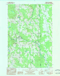
1984 Map of Monticello
USGS Topo · Published 1984About this map
Monticello serves as the focal point of this northern Maine landscape, situated at the confluence of the North Branch Meduxnekeag River and various rural roads in Aroostook County. The area’s agrarian and local character is reflected in the numerous family and community landmarks, such as Jewells Corner, Camp Williams, and the Wellington Sch. Proximity to the international border is clearly indicated by the presence of Customs and the dividing line between the United States and Canada.
Find a feature on this map
43 named features on this map. Tap any name to fly to it.
Don’t see what you’re looking for? This feature index may not catch every label — zoom into the map to look around manually.
Map Details
Editions of this 1984 Monticello Map
This is the sole edition of this map. No revisions or reprints were ever made.
Other maps of this area

1934 · Bridgewater
USGS Topo · 1:48,000

1938 · Bridgewater
USGS Topo · 1:62,500

1938 · Houlton
USGS Topo · 1:62,500

1951 · Houlton
USGS Topo · 1:62,500

1951 · Bridgewater
USGS Topo · 1:62,500

1953 · Bridgewater
USGS Topo · 1:50,000

1959 · Woodstock
USGS Topo · 1:250,000

1963 · Woodstock
USGS Topo · 1:250,000
1975 · Houlton NW
USGS Topo · 1:24,000
1975 · Houlton NE
USGS Topo · 1:24,000