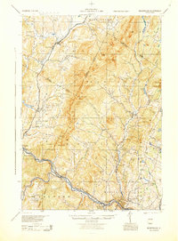
1988 Map of Montpelier
USGS Topo · Published 1988About this map
The Winooski River and the Central Vermont railroad define the industrial and transit corridor of this mid-century Vermont landscape, anchoring the state capital and its surrounding villages. The map reveals a dense network of district schools, such as Pucker Street Sch and Loomis Hill Sch, which reflect the distributed rural population of the era. Settlement patterns follow the river valleys and mountain gaps, with Middlesex Notch and Waterbury Center serving as key nodes between the high peaks of the Worcester Mountains.
Find a feature on this map
100 named features on this map. Tap any name to fly to it.
Don’t see what you’re looking for? This feature index may not catch every label — zoom into the map to look around manually.
Map Details
Editions of this 1988 Montpelier Map
2 editions found
Other maps of this area

1896 · Strafford
USGS Topo · 1:62,500

1902 · Brandon
USGS Topo · 1:62,500

1903 · Middlebury
USGS Topo · 1:62,500

1904 · Brandon
USGS Topo · 1:62,500

1905 · Middlebury
USGS Topo · 1:62,500

1906 · Burlington
USGS Topo · 1:62,500

1913 · Milton
USGS Topo · 1:48,000

1915 · Milton
USGS Topo · 1:62,500

1915 · Rochester
USGS Topo · 1:62,500

1917 · Rochester
USGS Topo · 1:62,500