
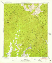
1935 Map of Montreat
USGS Topo · Published 1935About this map
Montreat and its surrounding peaks define this 1935 survey, which details the high-altitude landscape where the Black Mountains and Blue Ridge meet. The settlement is centered around Lake Susan, with the Brookside Sch and several local congregations like Mountain View Ch and Homers Chapel serving the valley. To the west, the Asheville Water Supply catchment area dominates the upper Swannanoa River drainage, while the northern boundary reaches the high summits of Mt Mitchell and Clingmans Peak within Mt Mitchell State Park. The map documents a transition in mountain access, showing a Toll Road and Toll Gate ascending toward the peaks, alongside earlier backcountry landmarks like Walkertown and the Gaging Station on the North Fork. Numerous gaps, such as Balsam Gap and Rainbow Gap, illustrate the natural corridors used for travel through these steep divide lines.
Find a feature on this map
107 named features on this map. Tap any name to fly to it.
Don’t see what you’re looking for? This feature index may not catch every label — zoom into the map to look around manually.
Map Details
Editions of this 1935 Montreat Map
This is the sole edition of this map. No revisions or reprints were ever made.
Other maps of this area

1900 · Mount Mitchell
USGS Topo · 1:125,000

1902 · Mount Mitchell
USGS Topo · 1:125,000

1934 · Parts Of Celo And Black Brothers
USGS Topo · 1:24,000

1934 · Parts Of Old Fort and Montreat
USGS Topo · 1:24,000

1935 · Black Brothers
USGS Topo · 1:24,000

1935 · Black Mountain
USGS Topo · 1:24,000

1935 · Barnardsville
USGS Topo · 1:24,000

1935 · Craggy Pinnacle
USGS Topo · 1:24,000

1941 · Black Mountain
USGS Topo · 1:24,000
1942 · Montreat
USGS Topo · 1:24,000