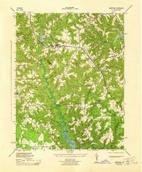
1944 Map of Montross
USGS Topo · Published 1944About this map
Montross serves as the focal point of this Northern Neck landscape during the mid-1940s, situated at a critical crossroads where the boundaries of Stonewall and Marshall meet. The area is characterized by a dense network of wooded swamps and tidal creeks, including the expansive Grand Mammy Swamp and the winding course of Cat Point Creek leading toward Menokin Bay. This topographic record reveals a deeply established rural community defined by its numerous small schoolhouses and country churches, such as Andrew Chapel and Welcome Grove Ch.
Find a feature on this map
64 named features on this map. Tap any name to fly to it.
Don’t see what you’re looking for? This feature index may not catch every label — zoom into the map to look around manually.
Map Details
Editions of this 1944 Montross Map
This is the sole edition of this map. No revisions or reprints were ever made.
Other maps of this area

1892 · Piney Point
USGS Topo · 1:62,500

1892 · Montross
USGS Topo · 1:62,500

1894 · Piney Point
USGS Topo · 1:62,500

1895 · Nomini
USGS Topo · 1:125,000

1895 · Piney Point
USGS Topo · 1:62,500

1895 · Montross
USGS Topo · 1:62,500

1898 · Nomini
USGS Topo · 1:125,000

1901 · Piney Point
USGS Topo · 1:62,500

1917 · Morattico
USGS Topo · 1:62,500

1918 · Tappahannock
USGS Topo · 1:62,500