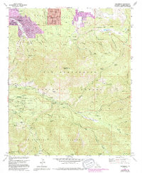
1959 Map of Moonridge
USGS Topo · Published 1994About this map
Bear Valley settlements and recreational camps define this high-altitude landscape south of Big Bear Lake. Residential clusters like Moonridge, Sugarloaf, and Woodlands are concentrated in the north, while the southern reaches transition into the protected San Bernardino National Forest and San Gorgonio Wilderness. The area is a significant hub for organized camping and outdoor tourism, evidenced by a dense concentration of facilities such as Camp Akela, Promised Land Camp, University Camp, and Mile High Pines Camp.
Find a feature on this map
87 named features on this map. Tap any name to fly to it.
Don’t see what you’re looking for? This feature index may not catch every label — zoom into the map to look around manually.
Map Details
Editions of this 1959 Moonridge Map
This is the sole edition of this map. No revisions or reprints were ever made.
Other maps of this area

1901 · Southern California Sheet No. 1
USGS Topo · 1:250,000

1902 · San Gorgonio
USGS Topo · 1:125,000

1904 · Southern California Sheet No. 1
USGS Topo · 1:250,000

1947 · Lucerne Valley
USGS Topo · 1:62,500

1949 · Lucerne Valley
USGS Topo · 1:62,500

1953 · San Bernardino
USGS Topo · 1:250,000

1954 · San Gorgonio Mountain
USGS Topo · 1:62,500

1955 · Old Woman Springs
USGS Topo · 1:62,500

1955 · Morongo Valley
USGS Topo · 1:62,500

1956 · San Bernardino
USGS Topo · 1:250,000