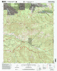
1996 Map of Moonridge
USGS Topo · Published 1999About this map
Barton Flats and the surrounding high-altitude landscapes of the San Bernardino National Forest appear in high detail on this 1990s revision. The map illustrates a dense concentration of seasonal and youth camps south of the Santa Ana River, including Camp River Glen, Camp Morningstar, and Camp Mile High Pines, reflecting the area's long-standing role as a recreational refuge. To the north, the residential communities of Moonridge and Sugarloaf border the Bear Mountain Ski Area, showing the transition from mountain settlements to protected wilderness.
Find a feature on this map
77 named features on this map. Tap any name to fly to it.
Don’t see what you’re looking for? This feature index may not catch every label — zoom into the map to look around manually.
Map Details
Editions of this 1996 Moonridge Map
This is the sole edition of this map. No revisions or reprints were ever made.
Other maps of this area

1901 · Southern California Sheet No. 1
USGS Topo · 1:250,000

1902 · San Gorgonio
USGS Topo · 1:125,000

1904 · Southern California Sheet No. 1
USGS Topo · 1:250,000

1947 · Lucerne Valley
USGS Topo · 1:62,500

1949 · Lucerne Valley
USGS Topo · 1:62,500

1953 · San Bernardino
USGS Topo · 1:250,000

1954 · San Gorgonio Mountain
USGS Topo · 1:62,500

1955 · Old Woman Springs
USGS Topo · 1:62,500

1955 · Morongo Valley
USGS Topo · 1:62,500

1956 · San Bernardino
USGS Topo · 1:250,000