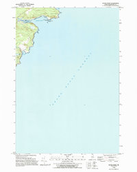
1993 Map of Moose River
USGS Topo · Published 1995About this map
Cutler's shoreline on the Gulf of Maine is the focus of this late-twentieth-century study, where the land meets the massive expanse of the Grand Manan Channel. The landscape is dominated by a complex intertidal zone and rocky coastal features, notably Eastern Head and the nearby Little Moose Island. Interior drainage patterns are clearly visible through the winding Moose River and the marshes of Bog Brook, which empties into the sheltered Bog Brook Cove.
Find a feature on this map
14 named features on this map. Tap any name to fly to it.
Don’t see what you’re looking for? This feature index may not catch every label — zoom into the map to look around manually.
Map Details
Editions of this 1993 Moose River Map
This is the sole edition of this map. No revisions or reprints were ever made.
Other maps of this area

1907 · Eastport
USGS Topo · 1:48,000

1908 · Eastport
USGS Topo · 1:62,500

1917 · Cutler
USGS Topo · 1:62,500

1918 · Cutler
USGS Topo · 1:62,500

1943 · Eastport
USGS Topo · 1:62,500

1945 · Eastport
USGS Topo · 1:62,500

1949 · Whiting
USGS Topo · 1:24,000

1949 · West Lubec
USGS Topo · 1:24,000
1949 · Moose River
USGS Topo · 1:24,000
1949 · Lubec
USGS Topo · 1:24,000