
1929 Map of Moosilauke
USGS Topo · Published 1959About this map
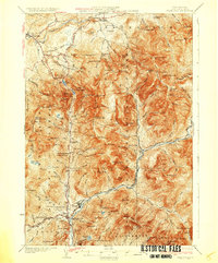
The Ammonoosuc River and its many tributaries, such as the Wild Ammonoosuc River, carve through the complex terrain of the White Mountain National Forest in this late-1920s topography. The map illustrates a rural landscape where industry and isolation meet, featuring the Boston and Maine RR following the river valley while remote landmarks like the Tiptop House and the State Sanitarium stand in the highlands.
Find a feature on this map
107 named features on this map. Tap any name to fly to it.
Don’t see what you’re looking for? This feature index may not catch every label — zoom into the map to look around manually.
Map Details
Editions of this 1929 Moosilauke Map
This is the sole edition of this map. No revisions or reprints were ever made.
Other maps of this area

1900 · Whitefield
USGS Topo · 1:62,500

1928 · Plymouth
USGS Topo · 1:62,500

1928 · Rumney
USGS Topo · 1:62,500

1929 · Franconia
USGS Topo · 1:62,500

1931 · Mt. Cube
USGS Topo · 1:62,500

1931 · Littleton
USGS Topo · 1:62,500

1931 · Plymouth
USGS Topo · 1:62,500

1931 · Woodsville
USGS Topo · 1:48,000
1932 · Franconia
USGS Topo · 1:62,500

1932 · Rumney
USGS Topo · 1:62,500