
1928 Map of Rumney
USGS Topo · Published 1955About this map
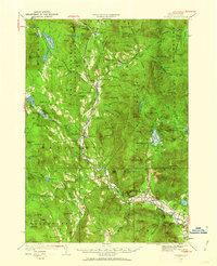
Baker River defines the central corridor of this Grafton County landscape, where the Boston and Maine Railroad connects a string of valley settlements during the late 1920s. The rail line is the primary artery for the region's economy, serving locations such as Glencliff, Swainboro Sta, and Rumney Depot. While the valley floors host clustered communities like Warren and Wentworth, the surrounding highlands are punctuated by isolated infrastructure and mountain landmarks. Notable upland features include the Stinson Mtn Fire Tower and mining sites like the Quarry and Ore Hill. The northeastern corner reveals the industrial footprint of the logging era with several numbered camps, including Camp No 4 and Camp No 5, situated along Hubbard Brook. Local education is well-represented by rural institutions like Maple Grove Sch and Buffalo Sch, providing a clear record of the area's early 20th-century social geography.
Find a feature on this map
111 named features on this map. Tap any name to fly to it.
Don’t see what you’re looking for? This feature index may not catch every label — zoom into the map to look around manually.
Map Details
Editions of this 1928 Rumney Map
3 editions found

Other maps of this area

1925 · Holderness
USGS Topo · 1:62,500

1927 · Holderness
USGS Topo · 1:62,500

1927 · Cardigan
USGS Topo · 1:62,500

1927 · Mascoma
USGS Topo · 1:62,500

1928 · Plymouth
USGS Topo · 1:62,500

1929 · Moosilauke
USGS Topo · 1:62,500

1929 · Franconia
USGS Topo · 1:62,500

1930 · Cardigan
USGS Topo · 1:62,500

1931 · Mt. Cube
USGS Topo · 1:62,500

1931 · Plymouth
USGS Topo · 1:62,500