
1925 Map of Holderness
USGS Topo · Published 1956About this map
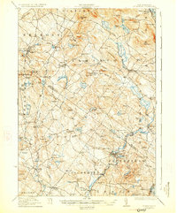
The Pemigewasset River carves through this central New Hampshire landscape, serving as a geographic anchor for the intersecting boundaries of Grafton, Belknap, and Merrimack counties. This mid-1920s survey documents a region defined by its significant water bodies, from the expansive Squam Lake with its numerous islands like Drakes Island and Kimble Island, to the southern reach of Winnisquam Lake. The Boston and Maine Railroad follows the river valley, connecting the established hubs of Ashland and Holderness to the broader regional economy.
Find a feature on this map
138 named features on this map. Tap any name to fly to it.
Don’t see what you’re looking for? This feature index may not catch every label — zoom into the map to look around manually.
Map Details
Editions of this 1925 Holderness Map
This is the sole edition of this map. No revisions or reprints were ever made.
Other maps of this area

1909 · Winnepesaukee
USGS Topo · 1:62,500

1919 · Gilmanton
USGS Topo · 1:62,500

1927 · Penacook
USGS Topo · 1:62,500
1927 · Gilmanton
USGS Topo · 1:62,500

1927 · Holderness
USGS Topo · 1:62,500

1927 · Cardigan
USGS Topo · 1:62,500

1928 · Mount Kearsarge
USGS Topo · 1:62,500

1928 · Plymouth
USGS Topo · 1:62,500

1928 · Rumney
USGS Topo · 1:62,500

1930 · Cardigan
USGS Topo · 1:62,500