
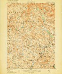
1919 Map of Gilmanton
USGS Topo · Published 1919About this map
Shaker Village and numerous agrarian hamlets anchor this landscape at the conclusion of the First World War, revealing a region defined by its reliance on small-scale water power and timber. The industrial character of the era is evident at Gilmanton Ironworks and the Carding Mill on the western edge of the quadrangle. Transportation is dominated by the Suncook Valley RR, which follows the path of the Suncook River through Pittsfield and into Chichester Sta.
Find a feature on this map
115 named features on this map. Tap any name to fly to it.
Don’t see what you’re looking for? This feature index may not catch every label — zoom into the map to look around manually.
Map Details
Editions of this 1919 Gilmanton Map
2 editions found
Other maps of this area

1909 · Winnepesaukee
USGS Topo · 1:62,500

1917 · Mt. Pawtuckaway
USGS Topo · 1:62,500

1919 · Mt. Pawtuckaway
USGS Topo · 1:62,500

1919 · Alton
USGS Topo · 1:62,500

1921 · Suncook
USGS Topo · 1:62,500

1925 · Holderness
USGS Topo · 1:62,500

1927 · Concord
USGS Topo · 1:62,500

1927 · Penacook
USGS Topo · 1:62,500

1927 · Gilmanton
USGS Topo · 1:62,500

1927 · Holderness
USGS Topo · 1:62,500