Old Maps of Merrimack County, New Hampshire
Explore 235 old maps of Merrimack County, spanning from 1902 to today. These high-resolution historic maps reveal how streets, neighborhoods, landmarks, and natural features evolved over time — perfect for genealogy, metal detecting, research, and local history exploration.
What you can do with these maps:
- See how Merrimack County changed over time: Compare historical maps to modern-day views to trace roads, homesites, rail lines & more.
- View detailed metadata: Each map includes creators, publishers, year, scale, and archive source.
- Overlay maps with satellite & LiDAR: Visualize the past alongside modern tools to explore terrain & human change.
- Trusted historical sources: Maps sourced from the USGS, Library of Congress, and other archives.
- Access maps your way: View online, download high-res files, or order prints for personal or research use.
Start exploring old maps of Merrimack County to uncover forgotten places, hidden landmarks, and the deep history beneath your feet.
Merrimack County, NH maps
(235)- 1902 Map of Sunapee, 1947 Print
 1902 Sunapee1947 Print · USGSSullivan County at the dawn of the twentieth century shows a vibrant landscape of lakeside landings and upland mill villages. Trace family roots and old transit routes from the Steamboat Route on Lake Sunapee to the Boston and Maine Railroad depots at Kelleyville and Wendell.
 - 1905 Map of Sunapee, 1947 Print
 1905 Sunapee1947 Print · USGSSullivan County's lakeside and rail economies are captured here just after the turn of the century. Genealogists can trace family lines through old post offices at North Newport PO and Mt Sunapee Chandler-ville PO, or follow the Steamboat Route to Soo Nipi Park.
 - 1907 Map of Sunapee
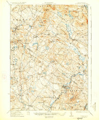
 1907 Sunapee1907 Print · USGSSullivan County at the dawn of the twentieth century was a landscape of mountain ridges and busy lakeside resorts. Genealogists can trace family names among the many peaks and locate local centers like Newport, Mill Village, and Blodgett Landing.7 unique versions available
 - 1919 Map of Gilmanton
 1919 Gilmanton1919 Print · USGSBelknap and Merrimack counties are mapped here just after the Great War, showing a landscape of specialized hamlets and water-driven industry. Researchers can trace the Suncook Valley RR and locate ancestral landmarks like Shaker Village or the Smith Meetinghouse.2 unique versions available
 - 1919 Map of Alton
 1919 Alton1919 Print · USGSEastern New Hampshire in the years following the Great War reveals a landscape of high ridges and valley settlements. Trace ancestral roots through small rural outposts like Middleton Corners and schools like the Willeytown School or Ten Rod School.6 unique versions available
 - 1921 Map of Suncook
 1921 Suncook1921 Print · USGSMerrimack and Suncook River valleys thrive in the early 1920s as bustling centers of rail travel and local education. Genealogists can locate family homesteads near dozens of rural schoolhouses like Borough School or trace the old Boston and Maine Railroad through Suncook and Hooksett.5 unique versions available
 - 1925 Map of Holderness, 1956 Print
 1925 Holderness1956 Print · USGSCentral New Hampshire in the mid-twenties centers on the Pemigewasset River and the bustling rail corridor. Genealogists can trace a network of rural schoolhouses like Sargent School and landmarks including Profile Falls and the Bay Meeting House.
 - 1926 Map of Hillsboro
 1926 Hillsboro1926 Print · USGSHillsborough County's mill towns and hill farms are captured here in the mid-1920s as the rail-and-river economy remained the local heartbeat. Researchers can trace the Boston and Maine line through Slab City or locate the Birthplace of Franklin Pierce near Jackman Reservoir.2 unique versions available
 - 1927 Map of Concord
 1927 Concord1927 Print · USGSMerrimack and Hillsborough counties show a landscape of river-driven industry and rural school districts during the mid-twenties. Genealogists can trace family lines through dozens of local schoolhouses and institutions like St Pauls School or the Quaker Church.6 unique versions available
 - 1927 Map of Penacook
 1927 Penacook1927 Print · USGSThe Merrimack and Winnipesaukee valleys in the mid-1920s reveal a landscape of river-powered industry and rural school districts. Researchers can trace dozens of family-named landmarks and institutions, from Kezer Seminary to the Soldiers Home and Swetts Mills.8 unique versions available
 - 1927 Map of Gilmanton
 1927 Gilmanton1927 Print · USGSBelknap and Merrimack Counties appear here in the late twenties, showing a landscape of rural schoolhouses and established hill towns. Genealogists can trace family names through landmarks like Smith Meetinghouse, Shaker Village, and the South Pittsfield Friends Meetinghouse.5 unique versions available
 - 1927 Map of Holderness
 1927 Holderness1927 Print · USGSThe Lakes Region in the late twenties reveals a landscape of small hill-town schools and winding river valleys. Genealogists can locate family landmarks like Sargent School, Dana Church, and numerous small waters from Squam Lake to Wickwas Pond.6 unique versions available
 - 1927 Map of Cardigan, 1957 Print
 1927 Cardigan1957 Print · USGSGrafton and Merrimack Counties were defined by rail-side industry and early lakeside tourism in the late 1920s. Genealogists and historians can trace defunct schoolhouses like School No 8 and find deep-woods sites like the Alexandria Mica Mine.
 - 1928 Map of Mount Kearsarge
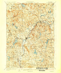
 1928 Mount Kearsarge1928 Print · USGSMerrimack County and the surrounding highlands are captured in the late 1920s as the rail-and-river economy flourished. Genealogists and historians can trace defunct schools and rural crossroads like Scribners Corner, the BOSTON AND MAINE RR corridor, and the COAL HEARTH CEMETERY.5 unique versions available
 - 1929 Map of Hillsboro
 1929 Hillsboro1929 Print · USGSCentral New Hampshire in the late twenties reveals a landscape of river-powered towns and remote hill farms. Trace family history at the Birthplace of Franklin Pierce or locate old schoolhouses like Liberty Union Sch and Hemlock Sch.5 unique versions available
 - 1930 Map of Cardigan
 1930 Cardigan1930 Print · USGSGrafton County's granite hills and lakeside settlements are captured here in the late prohibition era. Genealogists and hikers can trace the original locations of rural schoolhouses like Crawford Sch, the workings of the Alexandria Mica Mines, and the old rail stops at Grafton Sta.7 unique versions available
 - 1930 Map of Lovewell Mountain
 1930 Lovewell Mountain1930 Print · USGSThe Cheshire and Sullivan County borderlands come alive in this late 1920s survey of the New Hampshire highlands. Researchers can locate long-standing crossroads like East Lempster, find vanished rural education at Fifield Sch, or trace the old Loverens Mill site.4 unique versions available
 - 1931 Map of Mount Kearsarge
 1931 Mount Kearsarge1931 Print · USGSMerrimack County during the interwar years shows a New Hampshire landscape of river-powered hamlets and rail depots. Genealogists can trace family roots through specific sites like Coalhearth Cemetery, the Langley School, and junctions like Scribners Corner.
 - 1942 Map of Lovewell Mountain
 1942 Lovewell Mountain1942 Print · USGSSullivan and Cheshire Counties are shown in detail during the early 1940s, capturing the high-country pond and mill culture of the New Hampshire hills. Researchers can trace family roots through upland landmarks like Advent Ch, School No 5, and the old Meetinghouse.4 unique versions available
 - 1944 Map of Suncook
 1944 Suncook1944 Print · USGSSuncook and the surrounding New Hampshire hill towns are captured in the 1940s as industry met a rugged landscape. Trace ancestral homes and community hubs like Candia Station, the Sanitarium, and the Buck Street Sch during this era of transition.
 - 1949 Map of Portland
 1949 Portland1949 Print · USGSCoastal Maine and the New Hampshire interior are shown in detail during the late forties, from the bustling harbors to the lakeside villages. Researchers can trace historical rail networks like the Boston & Maine RR and locate coastal defenses such as Fort Preble.3 unique versions available
 - 1949 Map of Concord, 1954 Print
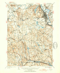 1949 Concord1954 Print · USGSMerrimack County at the close of the 1940s shows a capital city and its surrounding hill towns in transition. Genealogists and local historians can pinpoint family-named landmarks like Putney Hill, rural schoolhouses such as Waite School, and the quiet Quaker Church.4 unique versions available
 - 1950 Map of Glens Falls
 1950 Glens Falls1950 Print · USGSThe Adirondacks and the Green Mountains meet in this mid-century survey of the New York and Vermont borderlands. Researchers can trace the industrial rail corridors of the Rutland RR and Delaware & Hudson RR connecting Glens Falls, Rutland, and the shores of Lake George.
 - 1955 Map of Sunapee, 1957 Print
 1955 Sunapee1957 Print · USGSSullivan County in the mid-fifties is captured here as a landscape of granite ridges, industrial valleys, and developing lakefronts. Genealogists and historians can locate the Little Red Schoolhouse Museum, the Wayside Chapel, and active rail lines like the Boston and Maine RR.3 unique versions available
 - 1956 Map of Cardigan, 1958 Print
 1956 Cardigan1958 Print · USGSGrafton County's high ridges and lake shores are captured here during the mid-fifties, showing the region's transition toward recreation and conservation. Genealogists and hikers can trace the Boston and Maine rail line through Grafton Center or locate old district sites like the Red Sch and Alexandria Mica Mine.3 unique versions available
Showing maps 1-25 of 235
Top cities of Merrimack County
- Concord historical maps
- Hooksett historical maps
- Franklin historical maps
- Bow historical maps
- Pembroke historical maps
- Hopkinton historical maps
See more
Frequently asked questions
- What are the different types of historical maps available for Merrimack County?
- What is the oldest map of Merrimack County?
- Where can I purchase historical maps of Merrimack County for my home or office?
- Where can I download high-res historical maps of Merrimack County?
- Are there historical topographic maps available for Merrimack County?
- Is there historical aerial imagery available for Merrimack County?
- Where are historical maps of Merrimack County sourced from?