1960s Maps of Merrimack County, New Hampshire
Explore 10 historic maps of Merrimack County from the 1960s. These maps offer a rare glimpse into what life looked like during the 1960s — showing old roads, neighborhoods, homes, and landmarks that have changed or disappeared over time.
Whether you're researching your family's past, planning a metal detecting trip, or studying how Merrimack County's landscape evolved across the 1960s, these high-resolution maps are a powerful tool for exploring the history of this region.
- Focus on a specific era: All maps on this page are from the 1960s, giving you a focused view of this time period.
- See what’s changed: Compare century-old streets, trails, and buildings to today's modern landscape using overlays and satellite layers.
- Research with precision: Use these maps for genealogy, historical research, land use analysis, or educational projects.
- View, download, or print: Maps are fully viewable online in high resolution, and can be downloaded or printed for your own records.
Start exploring Merrimack County's history through authentic maps from the 1960s. This is your window into the past.
Merrimack County, NH maps
(10)- 1963 Map of Portland
 1963 Portland1963 Print · USGSCoastal Maine and New Hampshire thrived as maritime and industrial hubs during the mid-sixties, linked by a dense network of rail and river. Researchers can trace historic transit corridors like the Maine Central RR and locate key sites such as the Portsmouth Naval Shipyard or Pease Air Force Base.3 unique versions available
 - 1964 Map of Glens Falls
 1964 Glens Falls1964 Print · USGSThe tri-state borderlands of New York, Vermont, and New Hampshire appear here in the mid-1960s. Researchers can trace the rail routes of the Rutland RR and find historic sites like Ticonderoga and Saratoga National Historical Park.
 - 1967 Map of Gossville, 1971 Print
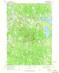 1967 Gossville1971 Print · USGSThe Suncook River valley and the highlands of Merrimack County are captured here in the late sixties as traditional village life met growing state parklands. Trace the route of the Suncook Valley RR and locate local landmarks like Epsom Central Sch or the McClary Cem.4 unique versions available
 - 1967 Map of Hopkinton, 1971 Print
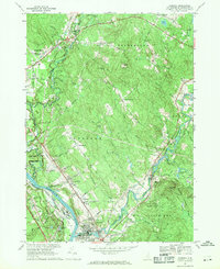
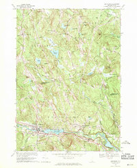
 1967 Hopkinton1971 Print · USGSMerrimack County during the late 1960s shows a landscape transformed by the Hopkinton-Everett Reservoir and modern highway interchanges. Researchers can trace ancestral roots at Putney Cem or explore the transit history of the Claremont and Concord Railroad and the landmark Covered Bridge.2 unique versions available
 - 1967 Map of Suncook, 1971 Print
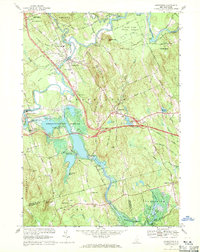
 1967 Suncook1971 Print · USGSMerrimack County communities are captured in the late sixties as the river-and-rail economy transitioned toward modern regional growth. Researchers can trace family roots at Stanley Cem, explore the historic Pembroke Academy, or follow the Boston and Maine Railroad through Suncook.3 unique versions available
 - 1967 Map of Weare, 1971 Print
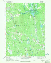 1967 Weare1971 Print · USGSHillsborough County in the late sixties reveals a landscape transformed by water management and historic New England settlement. Researchers can trace ancestral roots at Quaker Cem and Stark Cem or follow the Old Railroad Grade past Tavern Village.3 unique versions available
 - 1967 Map of Concord, 1971 Print
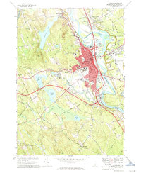 1967 Concord1971 Print · USGSConcord in the late sixties reveals the evolving character of New Hampshire's capital as modern turnpikes met the historic river corridor. Genealogists and historians can trace institutional landmarks like the State House and State Prison, or find family names at Blossom Hill Cemetery and Evan Cem.3 unique versions available
 - 1968 Map of Manchester North, 1971 Print
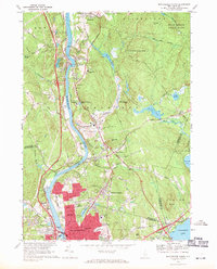 1968 Manchester North1971 Print · USGSThe northern edge of Manchester and the river-bound community of Hooksett are captured here in the late sixties as urban growth meets the wooded New Hampshire hills. Local historians can trace the paths of the Boston and Maine Railroad and find long-standing landmarks like Mt Saint Mary College and the Martin Cem.3 unique versions available
 - 1969 Map of Goffstown, 1971 Print
 1969 Goffstown1971 Print · USGSGoffstown and Dunbarton are captured here in the late sixties as the Piscataquog valley balanced its industrial rail heritage with residential growth. Genealogists can trace family plots in Westlawn Cem or Holy Trinity Cemetery and locate civic landmarks like the County Home.3 unique versions available
 - 1969 Map of Candia, 1971 Print
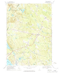 1969 Candia1971 Print · USGSRockingham County in the late sixties shows a landscape of wooded state parks and quiet rail corridors. Genealogists can locate family landmarks like the Holbrook Cem, the Moore Sch, and the Boston and Maine Railroad grade.2 unique versions available
End of results
Showing maps 1-10 of 10
Top cities of Merrimack County
- Concord historical maps
- Hooksett historical maps
- Franklin historical maps
- Bow historical maps
- Pembroke historical maps
- Hopkinton historical maps
See more
Frequently asked questions
- What are the different types of historical maps available for Merrimack County?
- What is the oldest map of Merrimack County?
- Where can I purchase historical maps of Merrimack County for my home or office?
- Where can I download high-res historical maps of Merrimack County?
- Are there historical topographic maps available for Merrimack County?
- Is there historical aerial imagery available for Merrimack County?
- Where are historical maps of Merrimack County sourced from?