1990s Maps of Merrimack County, New Hampshire
Explore 14 historic maps of Merrimack County from the 1990s. These maps offer a rare glimpse into what life looked like during the 1990s — showing old roads, neighborhoods, homes, and landmarks that have changed or disappeared over time.
Whether you're researching your family's past, planning a metal detecting trip, or studying how Merrimack County's landscape evolved across the 1990s, these high-resolution maps are a powerful tool for exploring the history of this region.
- Focus on a specific era: All maps on this page are from the 1990s, giving you a focused view of this time period.
- See what’s changed: Compare century-old streets, trails, and buildings to today's modern landscape using overlays and satellite layers.
- Research with precision: Use these maps for genealogy, historical research, land use analysis, or educational projects.
- View, download, or print: Maps are fully viewable online in high resolution, and can be downloaded or printed for your own records.
Start exploring Merrimack County's history through authentic maps from the 1990s. This is your window into the past.
Merrimack County, NH maps
(14)- 1995 Map of Goffstown, 1999 Print
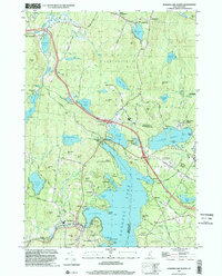
 1995 Goffstown1999 Print · USGSMerrimack County in the mid-1990s shows a transition from river-valley settlements to upland pond and hill country. Researchers can trace local history through sites like Holy Trinity Cemetery, the old crossroads at Dunbarton Center, and industrial landmarks near Goffstown.
 - 1995 Map of Hopkinton, 1999 Print
 1995 Hopkinton1999 Print · USGSMerrimack County during the 1990s shows a landscape shaped by the Contoocook River and major water control projects. Researchers can trace historic cemeteries like Davisville Cem, the rail lines of the Contoocook Valley Railroad, and local landmarks like the Maple Street Sch.
 - 1995 Map of Weare, 1999 Print
 1995 Weare1999 Print · USGSHillsborough County villages and the Piscataquog valley are captured here in the mid-nineties. Genealogists and local historians can trace the Old Railroad Grade past Tavern Village or locate family plots at Quaker Cem and Pine Grove Cem.
 - 1995 Map of Henniker, 1999 Print
 1995 Henniker1999 Print · USGSHenniker and the upper Contoocook River valley are shown in the mid-nineties as the area balanced its industrial past with forest conservation. Researchers can trace the path of the Old Railroad Grade past West Henniker or locate family landmarks like Morrill Hill and Colby Hill.
 - 1995 Map of Gossville, 1999 Print
 1995 Gossville1999 Print · USGSMerrimack and Rockingham County hills come into focus in the mid-nineties, showing the rural character of the Suncook River valley. Genealogists can locate family sites at McClary Cem, the Epsom Central Sch, and the old Suncook Valley Railroad corridor.
 - 1998 Map of New London, 2001 Print
 1998 New London2001 Print · USGSNew London and the surrounding hill towns are shown at the close of the twentieth century. Researchers can trace the layout of Colby Jr College, the historic station at South Danbury, and the village at Wilmot Flat.
 - 1998 Map of Deering, 2001 Print
 1998 Deering2001 Print · USGSThe hills of southern New Hampshire are captured here as they appeared in the late twentieth century. Genealogists and local historians can trace small settlements like Chase Village and Slab City, or locate family landmarks including Bartlett Hill and Goodale Hill.
 - 1998 Map of Bradford, 2001 Print
 1998 Bradford2001 Print · USGSCentral New Hampshire at the turn of the millennium shows a landscape defined by its lakes and conservation forests. Genealogists and local historians can trace the roads connecting North Sutton, Melvin Mills, and the Bradford Pines State Natural Area.
 - 1998 Map of Andover, 2001 Print
 1998 Andover2001 Print · USGSMerrimack County at the close of the twentieth century shows a landscape of mountain forests and clustered lakeside villages. Genealogists and local historians can trace the foundations of Potter Place, Cilleyville, and East Andover alongside the slopes of Mount Kearsarge.
 - 1998 Map of Hillsboro Upper Village, 2001 Print
 1998 Hillsboro Upper Village2001 Print · USGSHillsborough and Bradford counties are captured at the close of the twentieth century in this survey of south-central New Hampshire. Genealogists and historians can trace the rural layouts of Hillsboro Center and Bradford Center or locate family sites near Lake Massasecum.
 - 1998 Map of Warner, 2001 Print
 1998 Warner2001 Print · USGSThe Warner River valley in the late nineties shows a landscape of conserved forests and historic riverside hamlets. Researchers can trace old settlement patterns from Waterloo to Lower Village or locate family landmarks like Scribners Corner and Pumpkin Hill.
 - 1998 Map of Sunapee Lake North, 2002 Print
 1998 Sunapee Lake North2002 Print · USGSSullivan County lake life and upland forests are on full display in this late-nineties survey. Local researchers can trace family lands near Georges Mills, locate the Eastman Cem, and study the early resort footprints at Soo Nipi Park and Granliden.
 - 1998 Map of Washington, 2002 Print
 1998 Washington2002 Print · USGSSullivan County at the close of the twentieth century remains a landscape of deep woods and interconnected glacial ponds. Genealogists and hikers can trace the village layout of Washington or locate historic landmarks like Bradford Spring and the Center Sch.
 - 1998 Map of Sunapee Lake South, 2002 Print
 1998 Sunapee Lake South2002 Print · USGSMerrimack and Sullivan Counties at the close of the twentieth century show a landscape defined by forest conservation and mountain tourism. Researchers can trace the Old Railroad Grade and locate historic points like Blodgett Landing or Sunapee Station.
End of results
Showing maps 1-14 of 14
Top cities of Merrimack County
- Concord historical maps
- Hooksett historical maps
- Franklin historical maps
- Bow historical maps
- Pembroke historical maps
- Hopkinton historical maps
See more
Frequently asked questions
- What are the different types of historical maps available for Merrimack County?
- What is the oldest map of Merrimack County?
- Where can I purchase historical maps of Merrimack County for my home or office?
- Where can I download high-res historical maps of Merrimack County?
- Are there historical topographic maps available for Merrimack County?
- Is there historical aerial imagery available for Merrimack County?
- Where are historical maps of Merrimack County sourced from?