2000-2009 Maps of Merrimack County, New Hampshire
Explore 3 historic maps of Merrimack County from 2000-2009. These maps offer a rare glimpse into what life looked like during the 2000s — showing old roads, neighborhoods, homes, and landmarks that have changed or disappeared over time.
Whether you're researching your family's past, planning a metal detecting trip, or studying how Merrimack County's landscape evolved across the 2000s, these high-resolution maps are a powerful tool for exploring the history of this region.
- Focus on a specific era: All maps on this page are from the 2000s, giving you a focused view of this time period.
- See what’s changed: Compare century-old streets, trails, and buildings to today's modern landscape using overlays and satellite layers.
- Research with precision: Use these maps for genealogy, historical research, land use analysis, or educational projects.
- View, download, or print: Maps are fully viewable online in high resolution, and can be downloaded or printed for your own records.
Start exploring Merrimack County's history through authentic maps from the 2000s. This is your window into the past.
Merrimack County, NH maps
(3)- 2000 Map of Franklin, 2001 Print
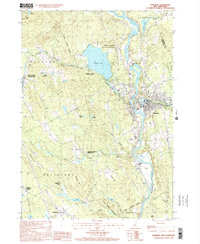 2000 Franklin2001 Print · USGSFranklin and its neighbors thrive at the turn of the millennium where the Pemigewasset and Winnipesaukee rivers meet. Genealogists and historians can trace local landmarks like the Daniel Webster Birthplace, the old Halcyon Sta, and Webster Place.
 - 2000 Map of Bristol, 2001 Print
 2000 Bristol2001 Print · USGSThe Pemigewasset River valley comes to life at the turn of the millennium, showing the intersecting boundaries of three New Hampshire counties. Researchers can trace the legacy of local conservation and industry through the New Hampton State Fish Hatchery and the high ridges of Huses Mountain.
 - 2000 Map of Webster, 2001 Print
 2000 Webster2001 Print · USGSMerrimack County at the close of the millennium reveals a landscape shaped by its river systems and early mill settlements. Researchers can trace the development of Dingit Corner and Swetts Mills or locate family landmarks near Pillsbury Lake.
End of results
Showing maps 1-3 of 3
Top cities of Merrimack County
- Concord historical maps
- Hooksett historical maps
- Franklin historical maps
- Bow historical maps
- Pembroke historical maps
- Hopkinton historical maps
See more
Frequently asked questions
- What are the different types of historical maps available for Merrimack County?
- What is the oldest map of Merrimack County?
- Where can I purchase historical maps of Merrimack County for my home or office?
- Where can I download high-res historical maps of Merrimack County?
- Are there historical topographic maps available for Merrimack County?
- Is there historical aerial imagery available for Merrimack County?
- Where are historical maps of Merrimack County sourced from?