1940s Maps of Merrimack County, New Hampshire
Explore 4 historic maps of Merrimack County from the 1940s. These maps offer a rare glimpse into what life looked like during the 1940s — showing old roads, neighborhoods, homes, and landmarks that have changed or disappeared over time.
Whether you're researching your family's past, planning a metal detecting trip, or studying how Merrimack County's landscape evolved across the 1940s, these high-resolution maps are a powerful tool for exploring the history of this region.
- Focus on a specific era: All maps on this page are from the 1940s, giving you a focused view of this time period.
- See what’s changed: Compare century-old streets, trails, and buildings to today's modern landscape using overlays and satellite layers.
- Research with precision: Use these maps for genealogy, historical research, land use analysis, or educational projects.
- View, download, or print: Maps are fully viewable online in high resolution, and can be downloaded or printed for your own records.
Start exploring Merrimack County's history through authentic maps from the 1940s. This is your window into the past.
Merrimack County, NH maps
(4)- 1942 Map of Lovewell Mountain
 1942 Lovewell Mountain1942 Print · USGSSullivan and Cheshire Counties are shown in detail during the early 1940s, capturing the high-country pond and mill culture of the New Hampshire hills. Researchers can trace family roots through upland landmarks like Advent Ch, School No 5, and the old Meetinghouse.4 unique versions available
 - 1944 Map of Suncook
 1944 Suncook1944 Print · USGSSuncook and the surrounding New Hampshire hill towns are captured in the 1940s as industry met a rugged landscape. Trace ancestral homes and community hubs like Candia Station, the Sanitarium, and the Buck Street Sch during this era of transition.
 - 1949 Map of Portland
 1949 Portland1949 Print · USGSCoastal Maine and the New Hampshire interior are shown in detail during the late forties, from the bustling harbors to the lakeside villages. Researchers can trace historical rail networks like the Boston & Maine RR and locate coastal defenses such as Fort Preble.3 unique versions available
 - 1949 Map of Concord, 1954 Print
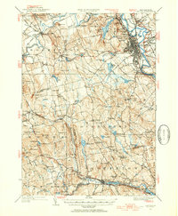 1949 Concord1954 Print · USGSMerrimack County at the close of the 1940s shows a capital city and its surrounding hill towns in transition. Genealogists and local historians can pinpoint family-named landmarks like Putney Hill, rural schoolhouses such as Waite School, and the quiet Quaker Church.4 unique versions available
End of results
Showing maps 1-4 of 4
Top cities of Merrimack County
- Concord historical maps
- Hooksett historical maps
- Franklin historical maps
- Bow historical maps
- Pembroke historical maps
- Hopkinton historical maps
See more
Frequently asked questions
- What are the different types of historical maps available for Merrimack County?
- What is the oldest map of Merrimack County?
- Where can I purchase historical maps of Merrimack County for my home or office?
- Where can I download high-res historical maps of Merrimack County?
- Are there historical topographic maps available for Merrimack County?
- Is there historical aerial imagery available for Merrimack County?
- Where are historical maps of Merrimack County sourced from?