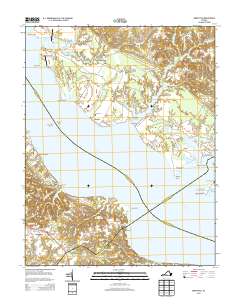
2014 Map of Morattico
USGS Topo · Published 2014About this map
The Rappahannock River serves as the central artery for this coastal landscape, where the boundaries of Richmond, Essex, Lancaster, and Middlesex counties converge over the water. Along the northern banks, the village of Sharps is marked by the Milden Cem, while further downstream, Morattico and Simonson anchor the Lancaster County shoreline. The map reveals a deeply tidal environment defined by numerous inlets and marshes, including Myrtle Swamp, Laton Swamp, and the winding course of Farnham Cr. Maritime infrastructure is evident at Bowlers Wharf and the Bowlers Rock Lighthouse, supporting the region's river-based economy. To the south, the community of Butylo sits near Butylo Bluff, overlooking the broad expanse of the river. Inland, small agricultural and residential centers like Ivondale, Simons Corner, and Laneview are connected by a network of local roads including the Tidewater Trl.
Find a feature on this map
55 named features on this map. Tap any name to fly to it.
Don’t see what you’re looking for? This feature index may not catch every label — zoom into the map to look around manually.
Map Details
Editions of this 2014 Morattico Map
This is the sole edition of this map. No revisions or reprints were ever made.
Other maps of this area

1917 · Urbanna
USGS Topo · 1:62,500

1917 · Morattico
USGS Topo · 1:62,500

1918 · Tappahannock
USGS Topo · 1:62,500

1918 · Morattico
USGS Topo · 1:62,500

1919 · New Kent
USGS Topo · 1:62,500

1919 · Tappahannock
USGS Topo · 1:62,500

1926 · Morattico
USGS Topo · 1:62,500

1943 · Richmond
USGS Topo · 1:250,000

1944 · Tappahannock
USGS Topo · 1:31,680

1944 · Dunnsville
USGS Topo · 1:31,680