
1944 Map of Dunnsville
USGS Topo · Published 1944About this map
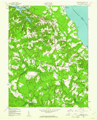
The Rappahannock River defines the eastern shoreline of this 1944 survey, where river-based commerce and inland milling shaped the community long before modern development. Historical landmarks like Wares Wharf and Bowlers Wharf mark the edge of the river, while industry moves inland along local creeks at sites such as Essex Mill and Smith and Rices Mill. This era also shows the importance of local education and faith in Essex County, evidenced by the Rappahannock Industrial Academy and Rappahannock Dist High School. The landscape is dominated by extensive wetlands including Dragon Swamp and Mill Swamp, which hem in the settlements of Dunnsville, Center Cross, and Ozeana. The intricate road network, featuring the George Washington Memorial Highway and Tidewater Trail, connects these rural outposts across a terrain of dense woodland and scattered orchards.
Find a feature on this map
43 named features on this map. Tap any name to fly to it.
Don’t see what you’re looking for? This feature index may not catch every label — zoom into the map to look around manually.
Map Details
Editions of this 1944 Dunnsville Map
2 editions found
Other maps of this area

1917 · Urbanna
USGS Topo · 1:62,500

1917 · Morattico
USGS Topo · 1:62,500

1918 · Tappahannock
USGS Topo · 1:62,500

1918 · Morattico
USGS Topo · 1:62,500

1919 · New Kent
USGS Topo · 1:62,500

1919 · Tappahannock
USGS Topo · 1:62,500

1926 · Morattico
USGS Topo · 1:62,500

1943 · Richmond
USGS Topo · 1:250,000

1944 · Mount Landing
USGS Topo · 1:31,680

1944 · Tappahannock
USGS Topo · 1:31,680