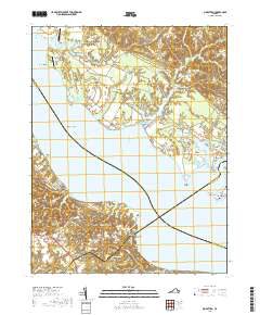
2019 Map of Morattico
USGS Topo · Published 2019About this map
Rappahannock River dominates this coastal landscape, where the borders of Richmond, Essex, Middlesex, and Lancaster counties meet amidst a network of tidal creeks and swamps. The river's influence is clear in the placement of historic waterfront settlements like Sharps and Morattico, alongside prominent land features such as Butylo Bluff and Tarpley Point. Local transportation and agriculture are represented by private airfields like Folly Neck Airport and Shandy Hall Farm Airport, reflecting a contemporary rural economy that still honors its roots through sites like Milden Cem and Emmanuel Cem. The intricate hydrology of the Northern Neck is mapped in detail, showing how Morattico Swamp and Myrtle Swamp feed into the larger river system. This survey provides a clear view of the area's transition from agricultural hinterlands at Simons Corner and Tidewater to the fishing and boating hubs along McKans Bay.
Find a feature on this map
100 named features on this map. Tap any name to fly to it.
Don’t see what you’re looking for? This feature index may not catch every label — zoom into the map to look around manually.
Map Details
Editions of this 2019 Morattico Map
This is the sole edition of this map. No revisions or reprints were ever made.
Other maps of this area

1917 · Urbanna
USGS Topo · 1:62,500

1917 · Morattico
USGS Topo · 1:62,500

1918 · Tappahannock
USGS Topo · 1:62,500

1918 · Morattico
USGS Topo · 1:62,500

1919 · New Kent
USGS Topo · 1:62,500

1919 · Tappahannock
USGS Topo · 1:62,500

1926 · Morattico
USGS Topo · 1:62,500

1943 · Richmond
USGS Topo · 1:250,000

1944 · Tappahannock
USGS Topo · 1:31,680

1944 · Dunnsville
USGS Topo · 1:31,680