
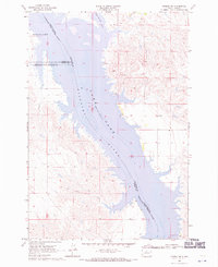
1968 Map of Moreau SE
USGS Topo · Published 1971About this map
The confluence of the Moreau River and the Lake Missouri Oahe River dominates this landscape, reflecting a period of significant hydrological change along the Missouri River system. The map captures the flooded river valley at a normal pool elevation of 1608 feet, where former terrestrial features are submerged or transformed into peninsulas and inlets. The Cheyenne River Indian Reservation Boundary cuts diagonally across the reservoir, marking a clear administrative division between Dewey and Walworth counties.
Find a feature on this map
14 named features on this map. Tap any name to fly to it.
Don’t see what you’re looking for? This feature index may not catch every label — zoom into the map to look around manually.
Map Details
Editions of this 1968 Moreau SE Map
This is the sole edition of this map. No revisions or reprints were ever made.
Other maps of this area

1953 · McIntosh
USGS Topo · 1:250,000

1958 · McIntosh
USGS Topo · 1:250,000

1968 · Moreau NW
USGS Topo · 1:24,000
1968 · Moreau NE
USGS Topo · 1:24,000
1968 · Akaska NW
USGS Topo · 1:24,000
1968 · Akaska SW
USGS Topo · 1:24,000

1968 · Moreau
USGS Topo · 1:24,000

1969 · Four Bear Creek
USGS Topo · 1:24,000
1970 · Steamboat Creek
USGS Topo · 1:24,000

1970 · Patch Skin Buttes
USGS Topo · 1:24,000