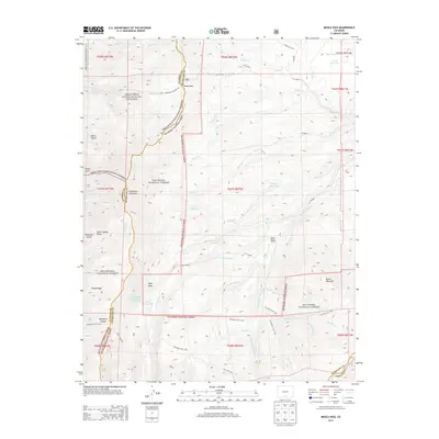
2013 Map of Mosca Pass
USGS Topo · Published 2013About this map
Mosca Pass serves as a central geographic anchor where the high desert terrain of the Great Sand Dunes National Preserve meets the steep eastern slopes of the Sangre de Cristo Mountains. This survey captures a transition between protected federal lands, including the Rio Grande National Forest and San Isabel National Forest, and the headwaters of the Huerfano River. The landscape is defined by deep drainages like Tellurium Gulch and Raspberry Canyon, as well as significant high-altitude water management features such as Smith Reservoir and Wilson Reservoir.
Find a feature on this map
68 named features on this map. Tap any name to fly to it.
Don’t see what you’re looking for? This feature index may not catch every label — zoom into the map to look around manually.
Map Details
Editions of this 2013 Mosca Pass Map
This is the sole edition of this map. No revisions or reprints were ever made.
Other maps of this area

1889 · Huerfano Park
USGS Topo · 1:125,000

1892 · Huerfano Park
USGS Topo · 1:125,000

1954 · Trinidad
USGS Topo · 1:250,000

1955 · Trinidad
USGS Topo · 1:250,000

1958 · Trinidad
USGS Topo · 1:250,000

1959 · Trinidad
USGS Topo · 1:250,000

1965 · Zapata Ranch
USGS Topo · 1:24,000

1965 · Twin Peaks
USGS Topo · 1:24,000

1967 · Mosca Pass
USGS Topo · 1:24,000
1967 · Blanca Peak
USGS Topo · 1:24,000