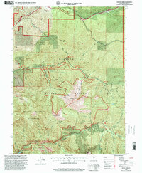
1998 Map of Mount Aire
USGS Topo · Published 2001About this map
Wasatch National Forest dominates this landscape, where the recreation and resource management of the late 20th century meet older industrial roots. The map details a complex network of canyons and peaks, including the high summits of Mount Raymond and Gobblers Knob. Evidence of the area's mining history is preserved at the Maxfield Mine and Baker Mine, while modern land use is reflected in numerous developed sites like the Church Fork Picnic Area and the Mountain-Dell Golf Course. Seasonal residential patterns are evident in established clusters such as the Porter Fork Summer Home Area and The Firz Summer Home Area. Significant protected lands are delineated within the Mount Olympus Wilderness and Twin Peaks Wilderness, showcasing the region's commitment to preserving its high-altitude environment alongside the Great Western Trail.
Find a feature on this map
89 named features on this map. Tap any name to fly to it.
Don’t see what you’re looking for? This feature index may not catch every label — zoom into the map to look around manually.
Map Details
Editions of this 1998 Mount Aire Map
This is the sole edition of this map. No revisions or reprints were ever made.
Other maps of this area

1885 · Salt Lake
USGS Topo · 1:250,000

1925 · Ft. Douglas
USGS Topo · 1:125,000

1928 · Ft. Douglas
USGS Topo · 1:125,000

1950 · Fort Douglas
USGS Topo · 1:24,000

1951 · Fort Douglas
USGS Topo · 1:24,000

1952 · Sugar House
USGS Topo · 1:24,000
1952 · Draper
USGS Topo · 1:24,000

1954 · Salt Lake City
USGS Topo · 1:250,000

1955 · Brighton
USGS Topo · 1:24,000

1955 · Mount Aire
USGS Topo · 1:24,000