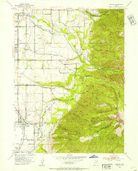
1952 Map of Draper
USGS Topo · Published 1954About this map
Draper and the surrounding Salt Lake Valley communities sit at the foot of the Wasatch Front in the early 1950s, showing a landscape transitioning from agricultural roots to modern infrastructure. The map documents an extensive irrigation network, including the Jordan and Salt Lake City Canal, the Salt Lake City Aqueduct, and the Draper Irrigation Ditch, which supported the region's farms and orchards. Local industry is represented by the Union Pacific rail line and the Mellen Sand Spur, alongside numerous gravel pits and the Historic Mon Temple Granite Quarry near the mouth of Little Cottonwood Canyon. Of particular interest to aviation and local history are the private airfields, Carters Sky Ranch and Alta Airpark, which operated before suburban expansion overtook the valley floor. Settlement centers like Union and Granite are clearly defined, providing a genealogical record of the area's development.
Find a feature on this map
54 named features on this map. Tap any name to fly to it.
Don’t see what you’re looking for? This feature index may not catch every label — zoom into the map to look around manually.
Map Details
Editions of this 1952 Draper Map
2 editions found
Other maps of this area

1885 · Salt Lake
USGS Topo · 1:250,000

1925 · Ft. Douglas
USGS Topo · 1:125,000

1928 · Ft. Douglas
USGS Topo · 1:125,000

1948 · Timpanogos Cave
USGS Topo · 1:24,000

1948 · Orem
USGS Topo · 1:62,500

1950 · Timpanogos Cave
USGS Topo · 1:24,000

1951 · Jordan Narrows
USGS Topo · 1:24,000

1951 · Lehi
USGS Topo · 1:24,000

1951 · Salt Lake City South
USGS Topo · 1:24,000

1951 · Midvale
USGS Topo · 1:24,000