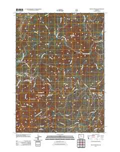
2011 Map of Mount Bolivar
USGS Topo · Published 2011About this map
Mount Bolivar and Diamond Peak anchor this section of Douglas County, where the high ridges of the Coast Range divide the drainage basins of the South Fork Coquille River and the West Fork Cow Creek. In the early 21st century, the landscape is defined by a dense network of timber and access roads, such as Nat For Dev RD 3348 and various BLM routes, reflecting the region's managed forest history. The presence of Fuller Mine and Bolivar Mine near the headwaters of Bolivar Creek points to the area's mineral exploration past. Higher elevations feature distinctive landmarks like Anaktuvuk Saddle and August Knob, while lower-lying areas like Ashur Flat and Big Prairie provide breaks in the continuous forest cover. For those tracking geography or resource history, the map clearly delineates the complex creek systems, including Mule Creek and Stanley Creek, that carve through this interior Oregon terrain.
Find a feature on this map
38 named features on this map. Tap any name to fly to it.
Don’t see what you’re looking for? This feature index may not catch every label — zoom into the map to look around manually.
Map Details
Editions of this 2011 Mount Bolivar Map
This is the sole edition of this map. No revisions or reprints were ever made.
Other maps of this area

1946 · Galice
USGS Topo · 1:62,500

1946 · Dutchman Butte
USGS Topo · 1:62,500

1948 · Galice
USGS Topo · 1:62,500

1948 · Dutchman Butte
USGS Topo · 1:62,500

1954 · Bone Mountain
USGS Topo · 1:62,500

1954 · Marial
USGS Topo · 1:62,500

1955 · Medford
USGS Topo · 1:250,000

1957 · Medford
USGS Topo · 1:250,000

1958 · Medford
USGS Topo · 1:250,000
1989 · Marial
USGS Topo · 1:24,000