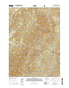
2014 Map of Mount Bolivar
USGS Topo · Published 2014About this map
Mount Bolivar stands as the central landmark of this terrain where Douglas, Coos, and Curry counties converge within the Siskiyou National Forest. The landscape is defined by its dramatic elevation changes and a dense network of watercourses, including the S Fork Coquille River and the numerous tributaries of West Fork Cow Creek. Named clearings and flats such as Ashur Flat, Big Prairie, and Walker Prairie suggest historical openings in the timber, while remote settlements like Eden Valley are tucked into the river valleys. Researchers can trace the rugged topography through named heights like Gold Mtn and Diamond Peak, or locate specific water sources like Porphyry Spring and Bolivar Spring. The presence of several Forest Service and BLM routes, including the Merial Jeep Rd and BLM-32-7-20, indicates the area's continued use for land management and backcountry access during this early 21st-century period.
Find a feature on this map
45 named features on this map. Tap any name to fly to it.
Don’t see what you’re looking for? This feature index may not catch every label — zoom into the map to look around manually.
Map Details
Editions of this 2014 Mount Bolivar Map
This is the sole edition of this map. No revisions or reprints were ever made.
Other maps of this area

1946 · Galice
USGS Topo · 1:62,500

1946 · Dutchman Butte
USGS Topo · 1:62,500

1948 · Galice
USGS Topo · 1:62,500

1948 · Dutchman Butte
USGS Topo · 1:62,500

1954 · Bone Mountain
USGS Topo · 1:62,500

1954 · Marial
USGS Topo · 1:62,500

1955 · Medford
USGS Topo · 1:250,000

1957 · Medford
USGS Topo · 1:250,000

1958 · Medford
USGS Topo · 1:250,000
1989 · Marial
USGS Topo · 1:24,000