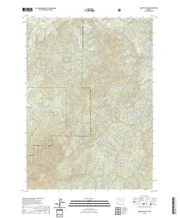
2024 Map of Mount Bolivar
USGS Topo · Published 2024About this map
Mount Bolivar stands as the central landmark in this southwestern Oregon landscape, marking a prominent point within the Wild Rogue Wilderness and the Siskiyou National Forest. The terrain is defined by a series of steep drainages and ridges, including Eden Ridge and Foggy Ridge, which funnel water toward the South Fork Coquille River in the west. This 2024 survey documents the modern boundary of Coos County as it traverses high-elevation points like August Knob and Anaktuvuk Saddle. The map reveals a mix of dense forest management and protected wilderness, where remote flats like Ashur Flat and high meadows like Big Prairie provide breaks in the vertical relief. Smaller peaks such as Diamond Peak and Gold Mtn populate the northern and central sections, illustrating the complex geography of the Klamath Mountains transition.
Find a feature on this map
23 named features on this map. Tap any name to fly to it.
Don’t see what you’re looking for? This feature index may not catch every label — zoom into the map to look around manually.
Map Details
Editions of this 2024 Mount Bolivar Map
This is the sole edition of this map. No revisions or reprints were ever made.
Other maps of this area

1946 · Galice
USGS Topo · 1:62,500

1946 · Dutchman Butte
USGS Topo · 1:62,500

1948 · Galice
USGS Topo · 1:62,500

1948 · Dutchman Butte
USGS Topo · 1:62,500

1954 · Bone Mountain
USGS Topo · 1:62,500

1954 · Marial
USGS Topo · 1:62,500

1955 · Medford
USGS Topo · 1:250,000

1957 · Medford
USGS Topo · 1:250,000

1958 · Medford
USGS Topo · 1:250,000
1989 · Marial
USGS Topo · 1:24,000