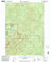
1998 Map of Mount Bolivar
USGS Topo · Published 2001About this map
Mount Bolivar rises as a prominent landmark at the intersection of the Siskiyou National Forest and Rogue River National Forest. This late-twentieth-century survey documents the complex geography where Coos, Douglas, and Curry counties meet. The landscape is defined by its drainage systems, including the South Fork Coquille River and the headwaters of Cow Creek. Historical resource extraction is evidenced by the Fuller Mine and several quarries scattered across the terrain, accompanied by remaining tailings.
Find a feature on this map
36 named features on this map. Tap any name to fly to it.
Don’t see what you’re looking for? This feature index may not catch every label — zoom into the map to look around manually.
Map Details
Editions of this 1998 Mount Bolivar Map
This is the sole edition of this map. No revisions or reprints were ever made.
Other maps of this area

1946 · Galice
USGS Topo · 1:62,500

1946 · Dutchman Butte
USGS Topo · 1:62,500

1948 · Galice
USGS Topo · 1:62,500

1948 · Dutchman Butte
USGS Topo · 1:62,500

1954 · Bone Mountain
USGS Topo · 1:62,500

1954 · Marial
USGS Topo · 1:62,500

1955 · Medford
USGS Topo · 1:250,000

1957 · Medford
USGS Topo · 1:250,000

1958 · Medford
USGS Topo · 1:250,000
1989 · Marial
USGS Topo · 1:24,000