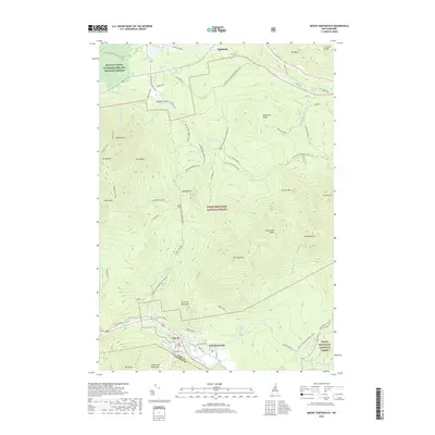
2018 Map of Mount Dartmouth
USGS Topo · Published 2018About this map
Fabyan and Bretton Woods anchor the southern reaches of this landscape, situated along the corridor of the Ammonoosuc River and Base Station Rd. This area of Coos County is defined by the high elevations of the White Mountain National Forest, where the Dartmouth Range and peaks like Mt Deception and Mt Martha dominate the terrain. To the north, the Israel River valley hosts small settlements such as Highlands and Walker Valley, connected by local routes like Valley Rd and the Presidential Rail Trail/Cohos Trail. The map documents a contemporary network of specialized transport, including the Cherry Mtn Jeep trail and numerous snowmobile routes like the Twenty Five Dollar Snomo (Snow), reflecting the region's shift toward recreational land use within the Silvio O Conte National Fish and Wildlife Refuge.
Find a feature on this map
64 named features on this map. Tap any name to fly to it.
Don’t see what you’re looking for? This feature index may not catch every label — zoom into the map to look around manually.
Map Details
Editions of this 2018 Mount Dartmouth Map
This is the sole edition of this map. No revisions or reprints were ever made.
Other maps of this area

1893 · Mt. Washington
USGS Topo · 1:62,500

1895 · Crawford Notch
USGS Topo · 1:62,500

1896 · Mt. Washington
USGS Topo · 1:62,500

1896 · Crawford Notch
USGS Topo · 1:62,500

1900 · Whitefield
USGS Topo · 1:62,500

1929 · Franconia
USGS Topo · 1:62,500

1932 · Franconia
USGS Topo · 1:62,500

1935 · Whitefield
USGS Topo · 1:48,000

1935 · Mt. Washington
USGS Topo · 1:62,500
1938 · Mt. Washington
USGS Topo · 1:62,500