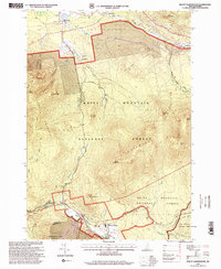
1995 Map of Mount Dartmouth
USGS Topo · Published 2000About this map
Lady of the Mountain Ch and the Church of the Transfiguration stand near the Ammonoosuc River, marking the spiritual and community centers of the southern valley in the mid-1990s. The landscape is defined by the high peaks of the White Mountain National Forest, including Mount Dartmouth and Cherry Mountain. Settlement is concentrated along the river corridor and the northern fringe near Highlands and Meadows, where the Rails and the Israel River pass through the northern forest boundary. This survey captures the region's character as a mountain destination, featuring the Golf Course at Bretton Woods and several backcountry landmarks like Fabyan Cabin. The geography here is heavily influenced by historic land grants, such as the Dartmouth College Grant and Crawfords Purchase, which dictate the boundaries of these protected New Hampshire woodlands.
Find a feature on this map
59 named features on this map. Tap any name to fly to it.
Don’t see what you’re looking for? This feature index may not catch every label — zoom into the map to look around manually.
Map Details
Editions of this 1995 Mount Dartmouth Map
This is the sole edition of this map. No revisions or reprints were ever made.
Other maps of this area

1893 · Mt. Washington
USGS Topo · 1:62,500

1895 · Crawford Notch
USGS Topo · 1:62,500

1896 · Mt. Washington
USGS Topo · 1:62,500

1896 · Crawford Notch
USGS Topo · 1:62,500

1900 · Whitefield
USGS Topo · 1:62,500

1929 · Franconia
USGS Topo · 1:62,500

1932 · Franconia
USGS Topo · 1:62,500

1935 · Whitefield
USGS Topo · 1:48,000

1935 · Mt. Washington
USGS Topo · 1:62,500
1938 · Mt. Washington
USGS Topo · 1:62,500