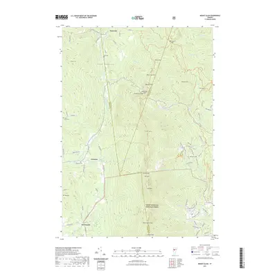
2021 Map of Mount Ellen
USGS Topo · Published 2021About this map
Mt Ellen and the high peaks of the Green Mountains dominate this survey of the central Vermont wilderness, where the long-distance Long Trl follows the spine of the range. The landscape is defined by its significant elevation changes, crossing through Appalachian Gap and Huntington Gap while passing over summits like Nancy Hanks Peak and Stark Mtn. Settlement is confined to the narrow valleys and lower slopes, with small communities like Jerusalem, Hanksville, and Downingville serving as focal points for local history. For genealogists, the map identifies small burial grounds such as Gore Cem and Little Ireland Cem, which are tucked away near watercourses like the Huntington River and Lewis Cr. Much of the eastern and southern portion of the quadrangle is protected within the Green Mountain National Forest, preserving the wooded character of the headwaters for Mill Brook and Slide Brook.
Find a feature on this map
94 named features on this map. Tap any name to fly to it.
Don’t see what you’re looking for? This feature index may not catch every label — zoom into the map to look around manually.
Map Details
Editions of this 2021 Mount Ellen Map
This is the sole edition of this map. No revisions or reprints were ever made.
Other maps of this area

1903 · Middlebury
USGS Topo · 1:62,500

1905 · Middlebury
USGS Topo · 1:62,500

1906 · Burlington
USGS Topo · 1:62,500

1919 · Burlington
USGS Topo · 1:62,500

1919 · Lincoln Mountain
USGS Topo · 1:62,500

1920 · Lincoln Mountain
USGS Topo · 1:48,000

1920 · Middlebury
USGS Topo · 1:62,500

1921 · Richmond
USGS Topo · 1:48,000

1921 · Lincoln Mountain
USGS Topo · 1:62,500

1924 · Camels Hump
USGS Topo · 1:62,500