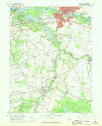
1967 Map of Mount Holly
USGS Topo · Published 1969About this map
Medford and Mount Holly serve as the primary hubs in this late 1960s survey of Burlington County, where the landscape is defined by the branching tributaries of the Rancocas Creek. The region exhibits a transition from established town centers to expanding residential developments like Rancocas Woods and Hoot Owl Estates. Historical industry remains visible through sites such as Kirbys Mill on the Southwest Branch Rancocas Creek and the Vincentown Millpond. The Penn Central railroad tracks cut through the terrain, connecting settlements like Hainesport and Lumberton. Local genealogy is well-represented by numerous landmarks, including St Marys Ch, Mt Moriah Cem, and the Eastern Union Cem. The presence of several airfields, such as the Flying W Ranch Airport and Red Lion Airport, highlights the area's increasing accessibility and suburban growth during this era.
Find a feature on this map
104 named features on this map. Tap any name to fly to it.
Don’t see what you’re looking for? This feature index may not catch every label — zoom into the map to look around manually.
Map Details
Editions of this 1967 Mount Holly Map
2 editions found
Other maps of this area

1888 · Bordentown
USGS Topo · 1:62,500

1888 · Pemberton
USGS Topo · 1:62,500

1888 · Mount Holly
USGS Topo · 1:62,500

1890 · Burlington
USGS Topo · 1:62,500

1893 · Bordentown
USGS Topo · 1:62,500

1893 · Burlington
USGS Topo · 1:62,500

1894 · Pemberton
USGS Topo · 1:62,500

1894 · Mount Holly
USGS Topo · 1:62,500

1898 · Pemberton
USGS Topo · 1:62,500

1898 · Mount Holly
USGS Topo · 1:62,500
Featured Places
- Mount Laurel Township, NJ
- Willingboro Township, NJ
- Medford Township, NJ
- Lumberton Township, NJ
- Mount Holly Township, NJ