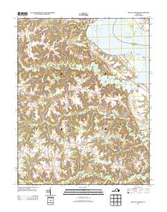
2013 Map of Mount Landing
USGS Topo · Published 2013About this map
The Rappahannock River defines the northeastern boundary of this Essex County landscape, where the tidal waters of Brecknock Bay and Mulberry Island meet a complex network of coastal tributaries. This modern survey illustrates the inland transition from riverfront points like Mallorys Point and Cedar Point to the agricultural interior. The road system is dominated by the Tidewater Trl and Mount Landing Rd, which connect a series of small, dispersed settlements including Caret, Rexburg, and Pigeon Hill.
Find a feature on this map
37 named features on this map. Tap any name to fly to it.
Don’t see what you’re looking for? This feature index may not catch every label — zoom into the map to look around manually.
Map Details
Editions of this 2013 Mount Landing Map
This is the sole edition of this map. No revisions or reprints were ever made.
Other maps of this area

1889 · Fredericksburg
USGS Topo · 1:125,000

1892 · Fredericksburg
USGS Topo · 1:125,000

1892 · Montross
USGS Topo · 1:62,500

1894 · Fredericksburg
USGS Topo · 1:125,000

1895 · Nomini
USGS Topo · 1:125,000

1895 · Montross
USGS Topo · 1:62,500

1898 · Nomini
USGS Topo · 1:125,000

1918 · Tappahannock
USGS Topo · 1:62,500

1918 · Aylett
USGS Topo · 1:62,500

1919 · Tappahannock
USGS Topo · 1:62,500