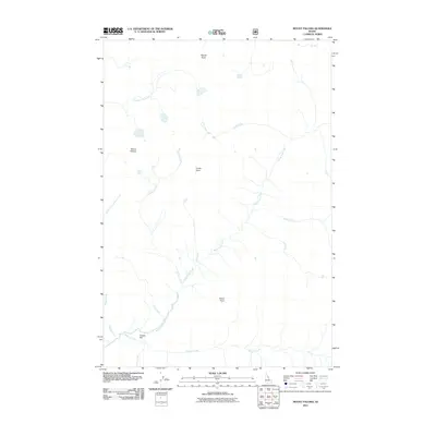
2011 Map of Mount Paloma
USGS Topo · Published 2011About this map
Mount Paloma and its neighboring peaks dominate this drainage system within the Idaho backcountry. The landscape is defined by a complex network of waterways, where Brushy Fork Creek and Clift Creek merge into the larger arterial system. To the south, Cooper Flat provides a rare point of level ground amidst the high relief of Vance Point and Cuneo Point. The drainage patterns are intricate, with Paloma Creek and White Cap Creek carving deep paths through the terrain. This 2011 survey by the U.S. Geological Survey shows a wilderness environment largely devoid of human infrastructure, focusing instead on the hydrographic relationships between Fall Creek, Granite Creek, and Canyon Creek. The detailed contour work illuminates the prominence of features like Nipple Knob, offering researchers a clear view of the natural topography in this portion of Idaho County.
Find a feature on this map
18 named features on this map. Tap any name to fly to it.
Don’t see what you’re looking for? This feature index may not catch every label — zoom into the map to look around manually.
Map Details
Editions of this 2011 Mount Paloma Map
This is the sole edition of this map. No revisions or reprints were ever made.
Other maps of this area

1901 · Hamilton
USGS Topo · 1:125,000

1911 · Lolo
USGS Topo · 1:250,000

1913 · Lolo
USGS Topo · 1:250,000

1956 · Elk City
USGS Topo · 1:250,000

1956 · Hamilton
USGS Topo · 1:250,000

1959 · Hamilton
USGS Topo · 1:250,000

1960 · Elk City
USGS Topo · 1:250,000

1960 · Hamilton
USGS Topo · 1:250,000

1964 · Hamilton
USGS Topo · 1:250,000
1964 · El Capitan
USGS Topo · 1:24,000