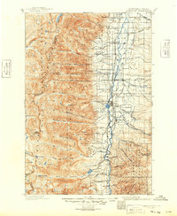
1964 Map of Hamilton
USGS Topo · Published 1964About this map
The Bitterroot Range forms a massive natural spine across this mid-century survey, dividing the high country of the Bitterroot National Forest and Clearwater National Forest. Along the eastern edge, the Bitterroot River valley is dotted with established settlements like Stevensville, Victor, and the county seat at Hamilton. This corridor shows a concentration of agricultural and civic development, including the fish hatchery and various ranger stations, contrasting sharply with the wilderness to the west. In the northern reaches, Missoula serves as a major hub where the Clark Fork meets the rail lines of the Northern Pacific and the electrified Chicago Milwaukee Saint Paul and Pacific. Historic routes like the Lolo Trail and Nez Perce Trail wind through the interior, marking traditional passage through terrain defined by peaks such as Saint Marys Peak and El Capitan.
Find a feature on this map
116 named features on this map. Tap any name to fly to it.
Don’t see what you’re looking for? This feature index may not catch every label — zoom into the map to look around manually.
Map Details
Editions of this 1964 Hamilton Map
This is the sole edition of this map. No revisions or reprints were ever made.
Historical Maps of Missoula Through Time
6 maps found