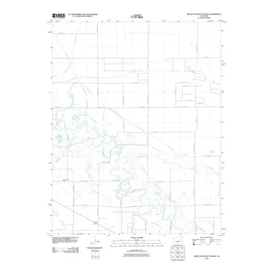
2010 Map of Mount Pleasant School
USGS Topo · Published 2010About this map
The Rio Grande meanders through this agricultural landscape in Alamosa County, Colorado, defining a complex system of water management essential to the high desert valley. The Mount Pleasant School stands as a focal point for the local rural community, surrounded by a dense grid of irrigation infrastructure. This network includes major waterways such as the San Luis Valley Canal, the Costilla Canal, and the Excelsior Ditch. Smaller arteries like the Hooper Lateral and Central Lateral crisscross the terrain, following the section lines of the rectangular survey system. The engineering of the landscape is further evidenced by drainage features like the Rio Grande Drain and Bowen Drain, which work in tandem with the supply canals to manage the basin's hydrology. This survey illustrates the intricate relationship between the river's natural course and the human-made diversions that have sustained local ranching and farming since the early settlement period.
Find a feature on this map
46 named features on this map. Tap any name to fly to it.
Don’t see what you’re looking for? This feature index may not catch every label — zoom into the map to look around manually.
Map Details
Editions of this 2010 Mount Pleasant School Map
This is the sole edition of this map. No revisions or reprints were ever made.
Other maps of this area

1915 · Del Norte
USGS Topo · 1:125,000

1917 · Del Norte
USGS Topo · 1:125,000

1922 · Conejos
USGS Topo · 1:125,000

1945 · Durango
USGS Topo · 1:250,000

1953 · Durango
USGS Topo · 1:250,000

1954 · Durango
USGS Topo · 1:250,000

1954 · Trinidad
USGS Topo · 1:250,000

1955 · Trinidad
USGS Topo · 1:250,000

1958 · Trinidad
USGS Topo · 1:250,000

1959 · Trinidad
USGS Topo · 1:250,000